You are here: Home > Network List > TA - USArray Transportable Network (new EarthScope stations) Stations List
> Station H18K Honhosa River, AK, USA > Earthquake Result Viewer
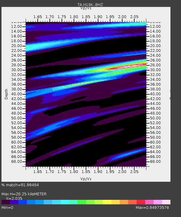
H18K Honhosa River, AK, USA - Earthquake Result Viewer
| Earthquake location: |
Off East Coast Of Honshu, Japan |
| Earthquake latitude/longitude: |
38.0/144.7 |
| Earthquake time(UTC): |
2017/09/20 (263) 16:37:16 GMT |
| Earthquake Depth: |
10 km |
| Earthquake Magnitude: |
6.1 Mww |
| Earthquake Catalog/Contributor: |
NEIC PDE/us |
|
| Network: |
TA USArray Transportable Network (new EarthScope stations) |
| Station: |
H18K Honhosa River, AK, USA |
| Lat/Lon: |
65.15 N/158.36 W |
| Elevation: |
494 m |
|
| Distance: |
42.5 deg |
| Az: |
31.633 deg |
| Baz: |
258.775 deg |
| Ray Param: |
0.073147625 |
| Estimated Moho Depth: |
28.25 km |
| Estimated Crust Vp/Vs: |
2.04 |
| Assumed Crust Vp: |
6.1 km/s |
| Estimated Crust Vs: |
2.998 km/s |
| Estimated Crust Poisson's Ratio: |
0.34 |
|
| Radial Match: |
91.99484 % |
| Radial Bump: |
335 |
| Transverse Match: |
71.069595 % |
| Transverse Bump: |
400 |
| SOD ConfigId: |
13570011 |
| Insert Time: |
2019-04-28 20:17:43.624 +0000 |
| GWidth: |
2.5 |
| Max Bumps: |
400 |
| Tol: |
0.001 |
|

Signal To Noise
| Channel | StoN | STA | LTA |
| TA:H18K: :BHZ:20170920T16:44:40.599995Z | 16.62413 | 2.915025E-6 | 1.7534903E-7 |
| TA:H18K: :BHN:20170920T16:44:40.599995Z | 5.5287247 | 4.712905E-7 | 8.524398E-8 |
| TA:H18K: :BHE:20170920T16:44:40.599995Z | 13.202062 | 1.4167745E-6 | 1.0731464E-7 |
| Arrivals |
| Ps | 5.1 SECOND |
| PpPs | 13 SECOND |
| PsPs/PpSs | 18 SECOND |


