You are here: Home > Network List > TA - USArray Transportable Network (new EarthScope stations) Stations List
> Station I21K Tanana, AK, USA > Earthquake Result Viewer
I21K Tanana, AK, USA - Earthquake Result Viewer
| Earthquake location: |
Off East Coast Of Honshu, Japan |
| Earthquake latitude/longitude: |
38.0/144.7 |
| Earthquake time(UTC): |
2017/09/20 (263) 16:37:16 GMT |
| Earthquake Depth: |
10 km |
| Earthquake Magnitude: |
6.1 Mww |
| Earthquake Catalog/Contributor: |
NEIC PDE/us |
|
| Network: |
TA USArray Transportable Network (new EarthScope stations) |
| Station: |
I21K Tanana, AK, USA |
| Lat/Lon: |
65.18 N/151.98 W |
| Elevation: |
248 m |
|
| Distance: |
45.2 deg |
| Az: |
32.145 deg |
| Baz: |
264.93 deg |
| Ray Param: |
0.0714646 |
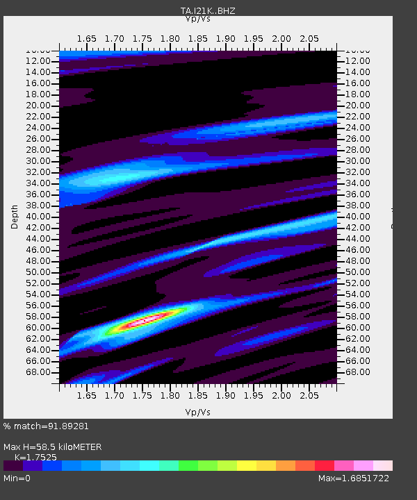
| Estimated Moho Depth: |
58.5 km |
| Estimated Crust Vp/Vs: |
1.75 |
| Assumed Crust Vp: |
6.566 km/s |
| Estimated Crust Vs: |
3.747 km/s |
| Estimated Crust Poisson's Ratio: |
0.26 |
|
| Radial Match: |
91.89281 % |
| Radial Bump: |
371 |
| Transverse Match: |
83.01364 % |
| Transverse Bump: |
400 |
| SOD ConfigId: |
13570011 |
| Insert Time: |
2019-04-28 20:17:53.861 +0000 |
| GWidth: |
2.5 |
| Max Bumps: |
400 |
| Tol: |
0.001 |
|

Signal To Noise
| Channel | StoN | STA | LTA |
| TA:I21K: :BHZ:20170920T16:45:02.025013Z | 36.185314 | 2.5280572E-6 | 6.986418E-8 |
| TA:I21K: :BHN:20170920T16:45:02.025013Z | 2.5078883 | 3.0597445E-7 | 1.2200482E-7 |
| TA:I21K: :BHE:20170920T16:45:02.025013Z | 8.70679 | 1.461786E-6 | 1.6789035E-7 |
| Arrivals |
| Ps | 7.2 SECOND |
| PpPs | 23 SECOND |
| PsPs/PpSs | 30 SECOND |


