You are here: Home > Network List > TA - USArray Transportable Network (new EarthScope stations) Stations List
> Station I29M Ogilvie Camp, Yukon, CA > Earthquake Result Viewer
I29M Ogilvie Camp, Yukon, CA - Earthquake Result Viewer
| Earthquake location: |
Off East Coast Of Honshu, Japan |
| Earthquake latitude/longitude: |
38.0/144.7 |
| Earthquake time(UTC): |
2017/09/20 (263) 16:37:16 GMT |
| Earthquake Depth: |
10 km |
| Earthquake Magnitude: |
6.1 Mww |
| Earthquake Catalog/Contributor: |
NEIC PDE/us |
|
| Network: |
TA USArray Transportable Network (new EarthScope stations) |
| Station: |
I29M Ogilvie Camp, Yukon, CA |
| Lat/Lon: |
65.36 N/138.31 W |
| Elevation: |
602 m |
|
| Distance: |
50.9 deg |
| Az: |
31.766 deg |
| Baz: |
277.094 deg |
| Ray Param: |
0.06775443 |
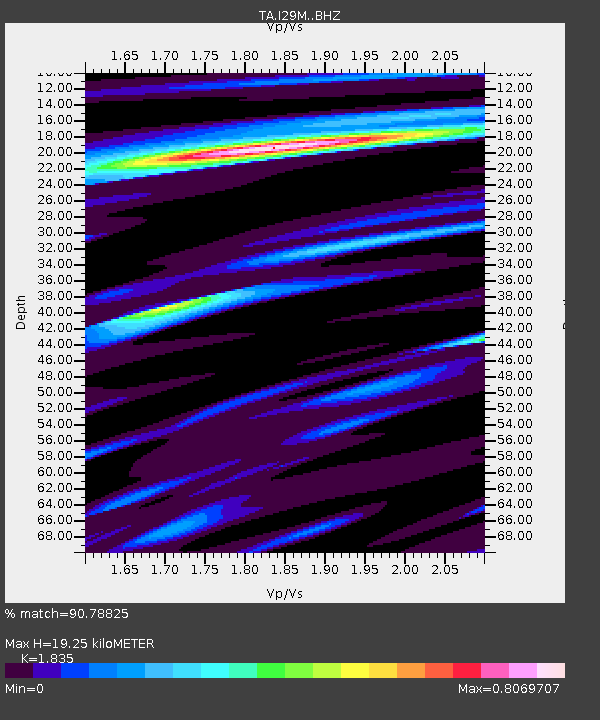
| Estimated Moho Depth: |
19.25 km |
| Estimated Crust Vp/Vs: |
1.84 |
| Assumed Crust Vp: |
6.566 km/s |
| Estimated Crust Vs: |
3.578 km/s |
| Estimated Crust Poisson's Ratio: |
0.29 |
|
| Radial Match: |
90.78825 % |
| Radial Bump: |
400 |
| Transverse Match: |
74.28429 % |
| Transverse Bump: |
400 |
| SOD ConfigId: |
13570011 |
| Insert Time: |
2019-04-28 20:17:58.373 +0000 |
| GWidth: |
2.5 |
| Max Bumps: |
400 |
| Tol: |
0.001 |
|

Signal To Noise
| Channel | StoN | STA | LTA |
| TA:I29M: :BHZ:20170920T16:45:46.349995Z | 34.26161 | 2.5581182E-6 | 7.466428E-8 |
| TA:I29M: :BHN:20170920T16:45:46.349995Z | 2.9339378 | 3.2202428E-7 | 1.0975839E-7 |
| TA:I29M: :BHE:20170920T16:45:46.349995Z | 16.391113 | 1.283616E-6 | 7.831171E-8 |
| Arrivals |
| Ps | 2.6 SECOND |
| PpPs | 7.8 SECOND |
| PsPs/PpSs | 10 SECOND |


