You are here: Home > Network List > TA - USArray Transportable Network (new EarthScope stations) Stations List
> Station K15K Wolf Creek Mountain, AK, USA > Earthquake Result Viewer
K15K Wolf Creek Mountain, AK, USA - Earthquake Result Viewer
| Earthquake location: |
Off East Coast Of Honshu, Japan |
| Earthquake latitude/longitude: |
38.0/144.7 |
| Earthquake time(UTC): |
2017/09/20 (263) 16:37:16 GMT |
| Earthquake Depth: |
10 km |
| Earthquake Magnitude: |
6.1 Mww |
| Earthquake Catalog/Contributor: |
NEIC PDE/us |
|
| Network: |
TA USArray Transportable Network (new EarthScope stations) |
| Station: |
K15K Wolf Creek Mountain, AK, USA |
| Lat/Lon: |
62.29 N/161.53 W |
| Elevation: |
346 m |
|
| Distance: |
40.5 deg |
| Az: |
35.467 deg |
| Baz: |
258.809 deg |
| Ray Param: |
0.074340284 |
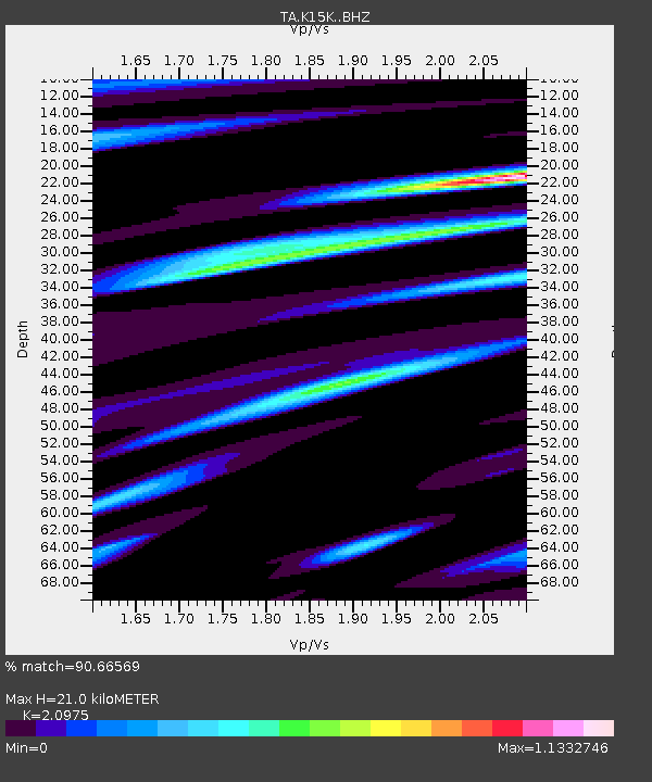
| Estimated Moho Depth: |
21.0 km |
| Estimated Crust Vp/Vs: |
2.10 |
| Assumed Crust Vp: |
6.276 km/s |
| Estimated Crust Vs: |
2.992 km/s |
| Estimated Crust Poisson's Ratio: |
0.35 |
|
| Radial Match: |
90.66569 % |
| Radial Bump: |
363 |
| Transverse Match: |
79.37772 % |
| Transverse Bump: |
400 |
| SOD ConfigId: |
13570011 |
| Insert Time: |
2019-04-28 20:18:07.344 +0000 |
| GWidth: |
2.5 |
| Max Bumps: |
400 |
| Tol: |
0.001 |
|

Signal To Noise
| Channel | StoN | STA | LTA |
| TA:K15K: :BHZ:20170920T16:44:24.700001Z | 21.466658 | 3.1403667E-6 | 1.4629043E-7 |
| TA:K15K: :BHN:20170920T16:44:24.700001Z | 1.1763427 | 2.8199554E-7 | 2.3972225E-7 |
| TA:K15K: :BHE:20170920T16:44:24.700001Z | 7.290834 | 1.8571739E-6 | 2.5472724E-7 |
| Arrivals |
| Ps | 3.9 SECOND |
| PpPs | 9.8 SECOND |
| PsPs/PpSs | 14 SECOND |


