You are here: Home > Network List > TA - USArray Transportable Network (new EarthScope stations) Stations List
> Station O04C Chester, CA, USA > Earthquake Result Viewer
O04C Chester, CA, USA - Earthquake Result Viewer
| Earthquake location: |
Mariana Islands |
| Earthquake latitude/longitude: |
21.0/144.7 |
| Earthquake time(UTC): |
2007/01/30 (030) 21:37:45 GMT |
| Earthquake Depth: |
30 km |
| Earthquake Magnitude: |
6.3 MB, 6.5 MS, 6.6 MW, 6.5 MW |
| Earthquake Catalog/Contributor: |
WHDF/NEIC |
|
| Network: |
TA USArray Transportable Network (new EarthScope stations) |
| Station: |
O04C Chester, CA, USA |
| Lat/Lon: |
40.32 N/121.09 W |
| Elevation: |
1513 m |
|
| Distance: |
79.8 deg |
| Az: |
50.781 deg |
| Baz: |
288.759 deg |
| Ray Param: |
0.04866729 |
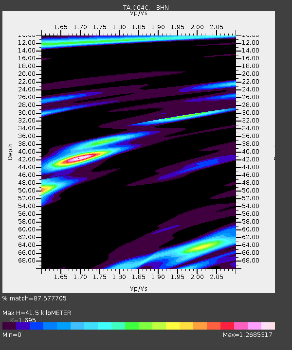
| Estimated Moho Depth: |
41.5 km |
| Estimated Crust Vp/Vs: |
1.70 |
| Assumed Crust Vp: |
6.566 km/s |
| Estimated Crust Vs: |
3.874 km/s |
| Estimated Crust Poisson's Ratio: |
0.23 |
|
| Radial Match: |
87.577705 % |
| Radial Bump: |
400 |
| Transverse Match: |
89.97716 % |
| Transverse Bump: |
400 |
| SOD ConfigId: |
2564 |
| Insert Time: |
2010-03-06 04:02:22.104 +0000 |
| GWidth: |
2.5 |
| Max Bumps: |
400 |
| Tol: |
0.001 |
|

Signal To Noise
| Channel | StoN | STA | LTA |
| TA:O04C: :BHN:20070130T21:49:20.048018Z | 1.3300833 | 3.5480443E-7 | 2.6675355E-7 |
| TA:O04C: :BHE:20070130T21:49:20.048018Z | 3.5799966 | 1.0413107E-6 | 2.908692E-7 |
| TA:O04C: :BHZ:20070130T21:49:20.048018Z | 9.521855 | 2.804904E-6 | 2.9457533E-7 |
| Arrivals |
| Ps | 4.5 SECOND |
| PpPs | 17 SECOND |
| PsPs/PpSs | 21 SECOND |


