You are here: Home > Network List > TA - USArray Transportable Network (new EarthScope stations) Stations List
> Station O04C Chester, CA, USA > Earthquake Result Viewer
O04C Chester, CA, USA - Earthquake Result Viewer
| Earthquake location: |
Near Coast Of Guatemala |
| Earthquake latitude/longitude: |
14.0/-91.2 |
| Earthquake time(UTC): |
2006/12/03 (337) 20:52:15 GMT |
| Earthquake Depth: |
61 km |
| Earthquake Magnitude: |
5.8 MB, 5.9 MW, 5.9 MW |
| Earthquake Catalog/Contributor: |
WHDF/NEIC |
|
| Network: |
TA USArray Transportable Network (new EarthScope stations) |
| Station: |
O04C Chester, CA, USA |
| Lat/Lon: |
40.32 N/121.09 W |
| Elevation: |
1513 m |
|
| Distance: |
37.0 deg |
| Az: |
320.759 deg |
| Baz: |
126.571 deg |
| Ray Param: |
0.07619444 |
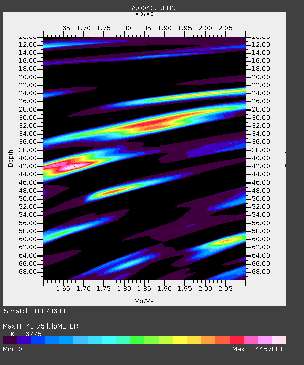
| Estimated Moho Depth: |
41.75 km |
| Estimated Crust Vp/Vs: |
1.68 |
| Assumed Crust Vp: |
6.566 km/s |
| Estimated Crust Vs: |
3.914 km/s |
| Estimated Crust Poisson's Ratio: |
0.22 |
|
| Radial Match: |
83.78683 % |
| Radial Bump: |
400 |
| Transverse Match: |
77.25001 % |
| Transverse Bump: |
400 |
| SOD ConfigId: |
2564 |
| Insert Time: |
2010-03-06 04:02:27.335 +0000 |
| GWidth: |
2.5 |
| Max Bumps: |
400 |
| Tol: |
0.001 |
|

Signal To Noise
| Channel | StoN | STA | LTA |
| TA:O04C: :BHN:20061203T20:58:49.373013Z | 1.794156 | 2.3147373E-7 | 1.2901539E-7 |
| TA:O04C: :BHE:20061203T20:58:49.373013Z | 1.5410589 | 2.6814772E-7 | 1.7400227E-7 |
| TA:O04C: :BHZ:20061203T20:58:49.373013Z | 4.18961 | 4.766867E-7 | 1.137783E-7 |
| Arrivals |
| Ps | 4.7 SECOND |
| PpPs | 16 SECOND |
| PsPs/PpSs | 20 SECOND |


