You are here: Home > Network List > TA - USArray Transportable Network (new EarthScope stations) Stations List
> Station MDND Maddock, ND, USA > Earthquake Result Viewer
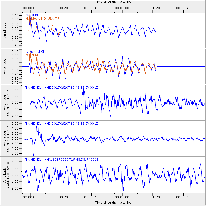
MDND Maddock, ND, USA - Earthquake Result Viewer
*The percent match for this event was below the threshold and hence no stack was calculated.
| Earthquake location: |
Off East Coast Of Honshu, Japan |
| Earthquake latitude/longitude: |
38.0/144.7 |
| Earthquake time(UTC): |
2017/09/20 (263) 16:37:16 GMT |
| Earthquake Depth: |
10 km |
| Earthquake Magnitude: |
6.1 Mww |
| Earthquake Catalog/Contributor: |
NEIC PDE/us |
|
| Network: |
TA USArray Transportable Network (new EarthScope stations) |
| Station: |
MDND Maddock, ND, USA |
| Lat/Lon: |
47.85 N/99.60 W |
| Elevation: |
479 m |
|
| Distance: |
77.2 deg |
| Az: |
38.485 deg |
| Baz: |
313.107 deg |
| Ray Param: |
$rayparam |
*The percent match for this event was below the threshold and hence was not used in the summary stack. |
|
| Radial Match: |
69.46058 % |
| Radial Bump: |
400 |
| Transverse Match: |
48.05499 % |
| Transverse Bump: |
400 |
| SOD ConfigId: |
13570011 |
| Insert Time: |
2019-04-28 20:18:33.531 +0000 |
| GWidth: |
2.5 |
| Max Bumps: |
400 |
| Tol: |
0.001 |
|
Signal To Noise
| Channel | StoN | STA | LTA |
| TA:MDND: :HHZ:20170920T16:48:38.74001Z | 14.221533 | 2.6739622E-6 | 1.8802209E-7 |
| TA:MDND: :HHN:20170920T16:48:38.74001Z | 1.5577089 | 9.0452033E-7 | 5.8067354E-7 |
| TA:MDND: :HHE:20170920T16:48:38.74001Z | 2.1626904 | 9.195968E-7 | 4.2520963E-7 |
| Arrivals |
| Ps | |
| PpPs | |
| PsPs/PpSs | |


