You are here: Home > Network List > TA - USArray Transportable Network (new EarthScope stations) Stations List
> Station O28M Mount Upton, YT, CAN > Earthquake Result Viewer
O28M Mount Upton, YT, CAN - Earthquake Result Viewer
| Earthquake location: |
Off East Coast Of Honshu, Japan |
| Earthquake latitude/longitude: |
38.0/144.7 |
| Earthquake time(UTC): |
2017/09/20 (263) 16:37:16 GMT |
| Earthquake Depth: |
10 km |
| Earthquake Magnitude: |
6.1 Mww |
| Earthquake Catalog/Contributor: |
NEIC PDE/us |
|
| Network: |
TA USArray Transportable Network (new EarthScope stations) |
| Station: |
O28M Mount Upton, YT, CAN |
| Lat/Lon: |
60.77 N/140.19 W |
| Elevation: |
2622 m |
|
| Distance: |
50.7 deg |
| Az: |
37.809 deg |
| Baz: |
279.237 deg |
| Ray Param: |
0.067881815 |
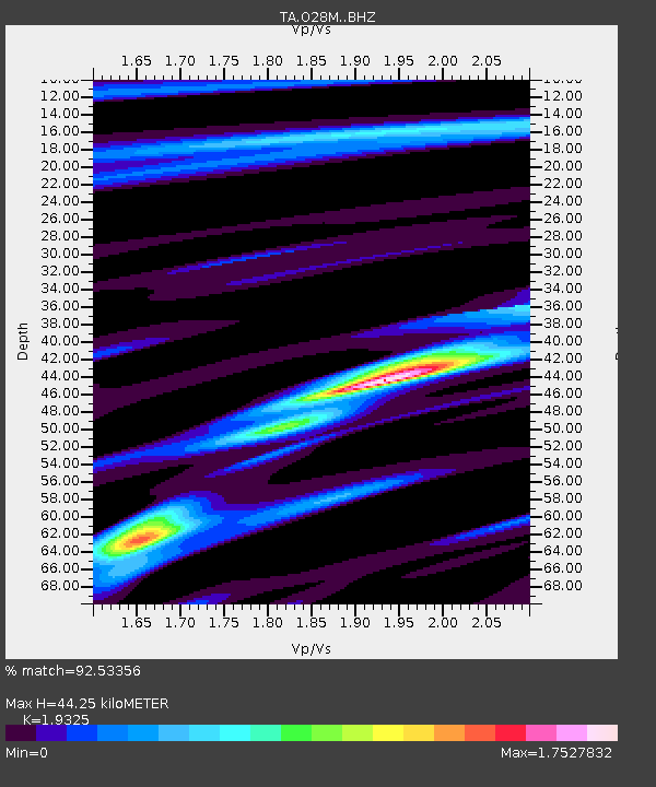
| Estimated Moho Depth: |
44.25 km |
| Estimated Crust Vp/Vs: |
1.93 |
| Assumed Crust Vp: |
6.566 km/s |
| Estimated Crust Vs: |
3.398 km/s |
| Estimated Crust Poisson's Ratio: |
0.32 |
|
| Radial Match: |
92.53356 % |
| Radial Bump: |
313 |
| Transverse Match: |
79.08046 % |
| Transverse Bump: |
400 |
| SOD ConfigId: |
13570011 |
| Insert Time: |
2019-04-28 20:18:51.040 +0000 |
| GWidth: |
2.5 |
| Max Bumps: |
400 |
| Tol: |
0.001 |
|
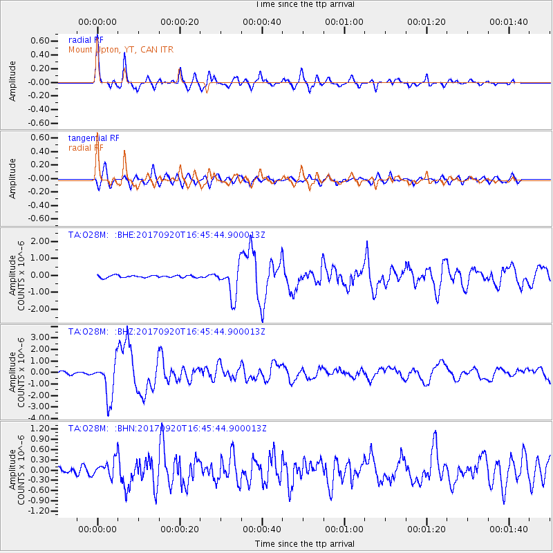
Signal To Noise
| Channel | StoN | STA | LTA |
| TA:O28M: :BHZ:20170920T16:45:44.900013Z | 16.875854 | 1.6771344E-6 | 9.938071E-8 |
| TA:O28M: :BHN:20170920T16:45:44.900013Z | 3.0191333 | 2.5126184E-7 | 8.322317E-8 |
| TA:O28M: :BHE:20170920T16:45:44.900013Z | 14.685304 | 9.657344E-7 | 6.5761974E-8 |
| Arrivals |
| Ps | 6.6 SECOND |
| PpPs | 19 SECOND |
| PsPs/PpSs | 25 SECOND |


