You are here: Home > Network List > TA - USArray Transportable Network (new EarthScope stations) Stations List
> Station P19K Oil Pt, AK, USA > Earthquake Result Viewer
P19K Oil Pt, AK, USA - Earthquake Result Viewer
| Earthquake location: |
Off East Coast Of Honshu, Japan |
| Earthquake latitude/longitude: |
38.0/144.7 |
| Earthquake time(UTC): |
2017/09/20 (263) 16:37:16 GMT |
| Earthquake Depth: |
10 km |
| Earthquake Magnitude: |
6.1 Mww |
| Earthquake Catalog/Contributor: |
NEIC PDE/us |
|
| Network: |
TA USArray Transportable Network (new EarthScope stations) |
| Station: |
P19K Oil Pt, AK, USA |
| Lat/Lon: |
59.65 N/153.23 W |
| Elevation: |
629 m |
|
| Distance: |
44.3 deg |
| Az: |
39.982 deg |
| Baz: |
269.395 deg |
| Ray Param: |
0.07200275 |
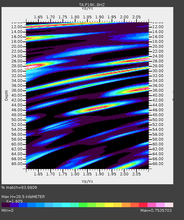
| Estimated Moho Depth: |
28.5 km |
| Estimated Crust Vp/Vs: |
1.61 |
| Assumed Crust Vp: |
5.989 km/s |
| Estimated Crust Vs: |
3.732 km/s |
| Estimated Crust Poisson's Ratio: |
0.18 |
|
| Radial Match: |
83.8609 % |
| Radial Bump: |
400 |
| Transverse Match: |
77.99464 % |
| Transverse Bump: |
400 |
| SOD ConfigId: |
13570011 |
| Insert Time: |
2019-04-28 20:18:56.972 +0000 |
| GWidth: |
2.5 |
| Max Bumps: |
400 |
| Tol: |
0.001 |
|

Signal To Noise
| Channel | StoN | STA | LTA |
| TA:P19K: :BHZ:20170920T16:44:55.224995Z | 25.5876 | 5.157717E-6 | 2.0157097E-7 |
| TA:P19K: :BHN:20170920T16:44:55.224995Z | 3.6328406 | 8.05756E-7 | 2.2179779E-7 |
| TA:P19K: :BHE:20170920T16:44:55.224995Z | 6.494829 | 1.6149836E-6 | 2.4865682E-7 |
| Arrivals |
| Ps | 3.1 SECOND |
| PpPs | 12 SECOND |
| PsPs/PpSs | 15 SECOND |


