You are here: Home > Network List > TA - USArray Transportable Network (new EarthScope stations) Stations List
> Station P32M Atlin, BC, CAN > Earthquake Result Viewer
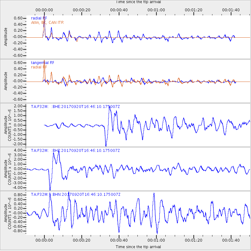
P32M Atlin, BC, CAN - Earthquake Result Viewer

| Earthquake location: |
Off East Coast Of Honshu, Japan |
| Earthquake latitude/longitude: |
38.0/144.7 |
| Earthquake time(UTC): |
2017/09/20 (263) 16:37:16 GMT |
| Earthquake Depth: |
10 km |
| Earthquake Magnitude: |
6.1 Mww |
| Earthquake Catalog/Contributor: |
NEIC PDE/us |
|
| Network: |
TA USArray Transportable Network (new EarthScope stations) |
| Station: |
P32M Atlin, BC, CAN |
| Lat/Lon: |
59.59 N/133.71 W |
| Elevation: |
793 m |
|
| Distance: |
54.1 deg |
| Az: |
38.405 deg |
| Baz: |
285.211 deg |
| Ray Param: |
0.06565254 |
| Estimated Moho Depth: |
35.25 km |
| Estimated Crust Vp/Vs: |
1.67 |
| Assumed Crust Vp: |
6.597 km/s |
| Estimated Crust Vs: |
3.951 km/s |
| Estimated Crust Poisson's Ratio: |
0.22 |
|
| Radial Match: |
87.80684 % |
| Radial Bump: |
400 |
| Transverse Match: |
73.75542 % |
| Transverse Bump: |
400 |
| SOD ConfigId: |
13570011 |
| Insert Time: |
2019-04-28 20:19:00.413 +0000 |
| GWidth: |
2.5 |
| Max Bumps: |
400 |
| Tol: |
0.001 |
|
Signal To Noise
| Channel | StoN | STA | LTA |
| TA:P32M: :BHZ:20170920T16:46:10.175007Z | 21.589018 | 1.8775895E-6 | 8.6969656E-8 |
| TA:P32M: :BHN:20170920T16:46:10.175007Z | 4.3666763 | 3.6757243E-7 | 8.4176705E-8 |
| TA:P32M: :BHE:20170920T16:46:10.175007Z | 7.815589 | 9.4189073E-7 | 1.2051436E-7 |
| Arrivals |
| Ps | 3.8 SECOND |
| PpPs | 13 SECOND |
| PsPs/PpSs | 17 SECOND |


