You are here: Home > Network List > TA - USArray Transportable Network (new EarthScope stations) Stations List
> Station R11B Troy Canyon, Currant, NV, USA > Earthquake Result Viewer
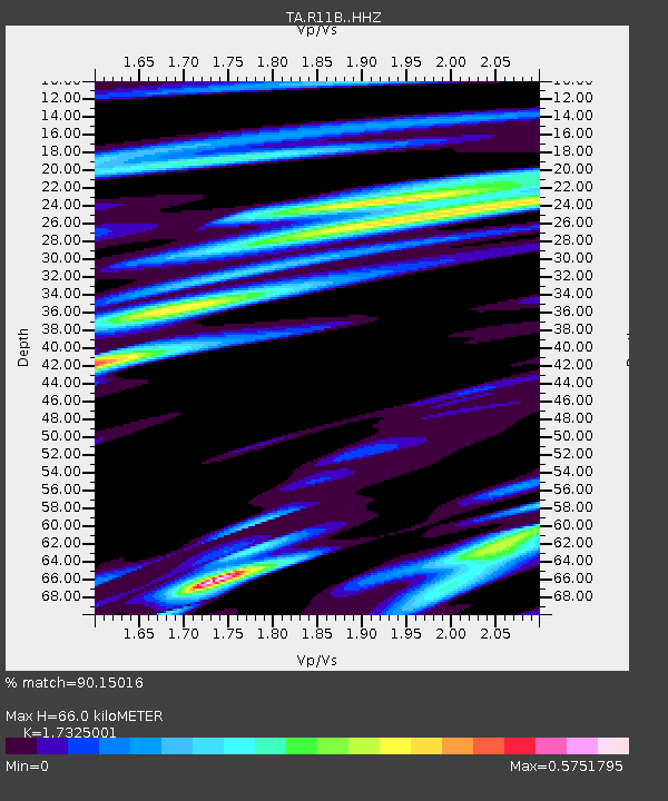
R11B Troy Canyon, Currant, NV, USA - Earthquake Result Viewer
| Earthquake location: |
Off East Coast Of Honshu, Japan |
| Earthquake latitude/longitude: |
38.0/144.7 |
| Earthquake time(UTC): |
2017/09/20 (263) 16:37:16 GMT |
| Earthquake Depth: |
10 km |
| Earthquake Magnitude: |
6.1 Mww |
| Earthquake Catalog/Contributor: |
NEIC PDE/us |
|
| Network: |
TA USArray Transportable Network (new EarthScope stations) |
| Station: |
R11B Troy Canyon, Currant, NV, USA |
| Lat/Lon: |
38.35 N/115.59 W |
| Elevation: |
1767 m |
|
| Distance: |
74.1 deg |
| Az: |
53.672 deg |
| Baz: |
305.936 deg |
| Ray Param: |
0.05254212 |
| Estimated Moho Depth: |
66.0 km |
| Estimated Crust Vp/Vs: |
1.73 |
| Assumed Crust Vp: |
6.276 km/s |
| Estimated Crust Vs: |
3.622 km/s |
| Estimated Crust Poisson's Ratio: |
0.25 |
|
| Radial Match: |
90.15016 % |
| Radial Bump: |
319 |
| Transverse Match: |
63.20832 % |
| Transverse Bump: |
400 |
| SOD ConfigId: |
13570011 |
| Insert Time: |
2019-04-28 20:19:08.634 +0000 |
| GWidth: |
2.5 |
| Max Bumps: |
400 |
| Tol: |
0.001 |
|

Signal To Noise
| Channel | StoN | STA | LTA |
| TA:R11B: :HHZ:20170920T16:48:21.329976Z | 9.275577 | 2.0285534E-6 | 2.1869836E-7 |
| TA:R11B: :HHN:20170920T16:48:21.329976Z | 5.412056 | 5.2063604E-7 | 9.619931E-8 |
| TA:R11B: :HHE:20170920T16:48:21.329976Z | 3.7821915 | 7.7561685E-7 | 2.0507076E-7 |
| Arrivals |
| Ps | 8.0 SECOND |
| PpPs | 28 SECOND |
| PsPs/PpSs | 36 SECOND |


