You are here: Home > Network List > TA - USArray Transportable Network (new EarthScope stations) Stations List
> Station O04C Chester, CA, USA > Earthquake Result Viewer
O04C Chester, CA, USA - Earthquake Result Viewer
| Earthquake location: |
Solomon Islands |
| Earthquake latitude/longitude: |
-6.8/155.5 |
| Earthquake time(UTC): |
2006/09/01 (244) 10:18:51 GMT |
| Earthquake Depth: |
38 km |
| Earthquake Magnitude: |
6.3 MB, 6.7 MS, 6.8 MW, 6.7 MW |
| Earthquake Catalog/Contributor: |
WHDF/NEIC |
|
| Network: |
TA USArray Transportable Network (new EarthScope stations) |
| Station: |
O04C Chester, CA, USA |
| Lat/Lon: |
40.32 N/121.09 W |
| Elevation: |
1513 m |
|
| Distance: |
89.3 deg |
| Az: |
49.426 deg |
| Baz: |
260.622 deg |
| Ray Param: |
0.04188549 |
| Estimated Moho Depth: |
10.0 km |
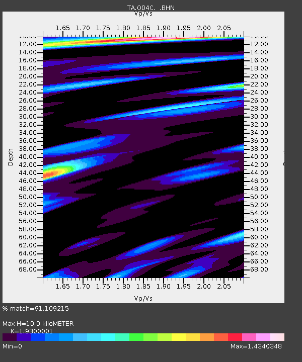
| Estimated Crust Vp/Vs: |
1.93 |
| Assumed Crust Vp: |
6.566 km/s |
| Estimated Crust Vs: |
3.402 km/s |
| Estimated Crust Poisson's Ratio: |
0.32 |
|
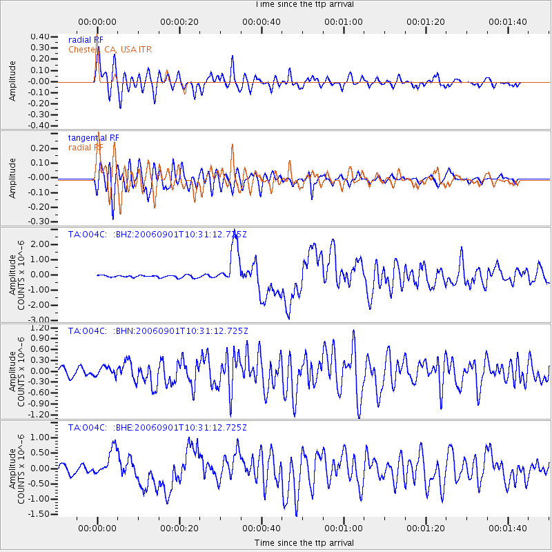
| Radial Match: |
91.109215 % |
| Radial Bump: |
400 |
| Transverse Match: |
84.356125 % |
| Transverse Bump: |
400 |
| SOD ConfigId: |
2665 |
| Insert Time: |
2010-03-06 04:02:47.889 +0000 |
| GWidth: |
2.5 |
| Max Bumps: |
400 |
| Tol: |
0.001 |
|
Signal To Noise
| Channel | StoN | STA | LTA |
| TA:O04C: :BHN:20060901T10:31:12.725Z | 0.74021095 | 1.3100505E-7 | 1.769834E-7 |
| TA:O04C: :BHE:20060901T10:31:12.725Z | 4.0720553 | 4.73508E-7 | 1.16282315E-7 |
| TA:O04C: :BHZ:20060901T10:31:12.725Z | 19.765528 | 1.4211306E-6 | 7.189945E-8 |
| Arrivals |
| Ps | 1.4 SECOND |
| PpPs | 4.4 SECOND |
| PsPs/PpSs | 5.8 SECOND |


