You are here: Home > Network List > II - Global Seismograph Network (GSN - IRIS/IDA) Stations List
> Station WRAB Tennant Creek, NT, Australia > Earthquake Result Viewer
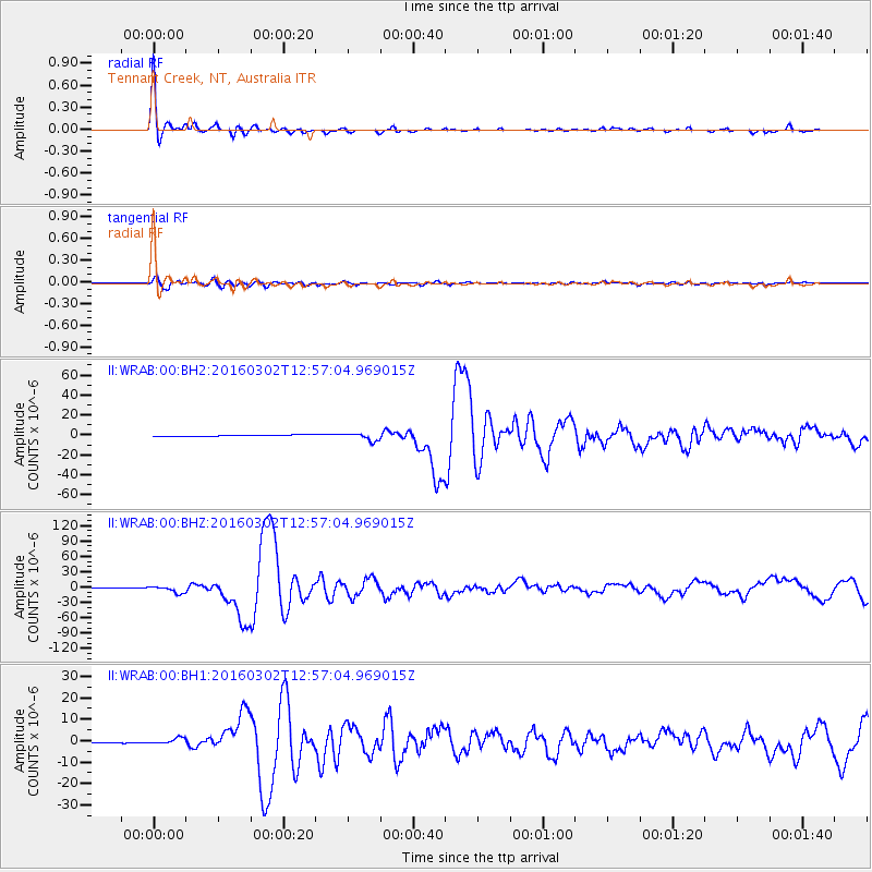
WRAB Tennant Creek, NT, Australia - Earthquake Result Viewer
| Earthquake location: |
Southwest Of Sumatra, Indonesia |
| Earthquake latitude/longitude: |
-4.9/94.2 |
| Earthquake time(UTC): |
2016/03/02 (062) 12:49:46 GMT |
| Earthquake Depth: |
10 km |
| Earthquake Magnitude: |
7.9 MWW |
| Earthquake Catalog/Contributor: |
NEIC PDE/NEIC COMCAT |
|
| Network: |
II Global Seismograph Network (GSN - IRIS/IDA) |
| Station: |
WRAB Tennant Creek, NT, Australia |
| Lat/Lon: |
19.93 S/134.36 E |
| Elevation: |
366 m |
|
| Distance: |
41.8 deg |
| Az: |
114.522 deg |
| Baz: |
285.519 deg |
| Ray Param: |
0.07356829 |
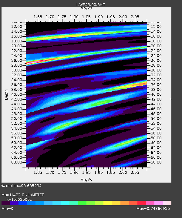
| Estimated Moho Depth: |
27.0 km |
| Estimated Crust Vp/Vs: |
1.60 |
| Assumed Crust Vp: |
6.642 km/s |
| Estimated Crust Vs: |
4.145 km/s |
| Estimated Crust Poisson's Ratio: |
0.18 |
|
| Radial Match: |
98.635284 % |
| Radial Bump: |
295 |
| Transverse Match: |
92.15405 % |
| Transverse Bump: |
400 |
| SOD ConfigId: |
1427151 |
| Insert Time: |
2016-03-16 13:10:36.413 +0000 |
| GWidth: |
2.5 |
| Max Bumps: |
400 |
| Tol: |
0.001 |
|
Signal To Noise
| Channel | StoN | STA | LTA |
| II:WRAB:00:BHZ:20160302T12:57:04.969015Z | 10.336246 | 6.564725E-6 | 6.35117E-7 |
| II:WRAB:00:BH1:20160302T12:57:04.969015Z | 7.3975077 | 1.3671946E-6 | 1.8481828E-7 |
| II:WRAB:00:BH2:20160302T12:57:04.969015Z | 6.2078705 | 3.8565017E-6 | 6.212278E-7 |
| Arrivals |
| Ps | 2.7 SECOND |
| PpPs | 9.8 SECOND |
| PsPs/PpSs | 12 SECOND |


