You are here: Home > Network List > TA - USArray Transportable Network (new EarthScope stations) Stations List
> Station S12K Black Hills, AK, USA > Earthquake Result Viewer
S12K Black Hills, AK, USA - Earthquake Result Viewer
| Earthquake location: |
Off East Coast Of Honshu, Japan |
| Earthquake latitude/longitude: |
38.0/144.7 |
| Earthquake time(UTC): |
2017/09/20 (263) 16:37:16 GMT |
| Earthquake Depth: |
10 km |
| Earthquake Magnitude: |
6.1 Mww |
| Earthquake Catalog/Contributor: |
NEIC PDE/us |
|
| Network: |
TA USArray Transportable Network (new EarthScope stations) |
| Station: |
S12K Black Hills, AK, USA |
| Lat/Lon: |
55.70 N/162.06 W |
| Elevation: |
411 m |
|
| Distance: |
39.4 deg |
| Az: |
45.621 deg |
| Baz: |
266.145 deg |
| Ray Param: |
0.075005144 |
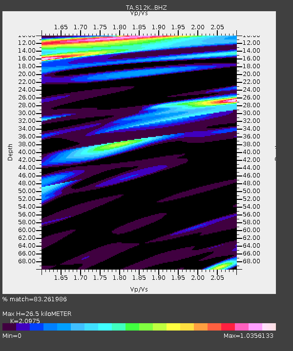
| Estimated Moho Depth: |
26.5 km |
| Estimated Crust Vp/Vs: |
2.10 |
| Assumed Crust Vp: |
5.989 km/s |
| Estimated Crust Vs: |
2.855 km/s |
| Estimated Crust Poisson's Ratio: |
0.35 |
|
| Radial Match: |
83.261986 % |
| Radial Bump: |
400 |
| Transverse Match: |
60.11619 % |
| Transverse Bump: |
400 |
| SOD ConfigId: |
13570011 |
| Insert Time: |
2019-04-28 20:19:14.543 +0000 |
| GWidth: |
2.5 |
| Max Bumps: |
400 |
| Tol: |
0.001 |
|

Signal To Noise
| Channel | StoN | STA | LTA |
| TA:S12K: :BHZ:20170920T16:44:15.249989Z | 2.3215852 | 2.0099446E-6 | 8.6576387E-7 |
| TA:S12K: :BHN:20170920T16:44:15.249989Z | 0.77210975 | 4.284901E-7 | 5.549601E-7 |
| TA:S12K: :BHE:20170920T16:44:15.249989Z | 1.3582722 | 1.0730466E-6 | 7.900086E-7 |
| Arrivals |
| Ps | 5.1 SECOND |
| PpPs | 13 SECOND |
| PsPs/PpSs | 18 SECOND |


