You are here: Home > Network List > TA - USArray Transportable Network (new EarthScope stations) Stations List
> Station O04C Chester, CA, USA > Earthquake Result Viewer
O04C Chester, CA, USA - Earthquake Result Viewer
| Earthquake location: |
Near East Coast Of Kamchatka |
| Earthquake latitude/longitude: |
51.1/157.5 |
| Earthquake time(UTC): |
2006/08/24 (236) 21:50:36 GMT |
| Earthquake Depth: |
43 km |
| Earthquake Magnitude: |
5.9 MB, 6.2 MS, 6.5 MW, 6.5 MW |
| Earthquake Catalog/Contributor: |
WHDF/NEIC |
|
| Network: |
TA USArray Transportable Network (new EarthScope stations) |
| Station: |
O04C Chester, CA, USA |
| Lat/Lon: |
40.32 N/121.09 W |
| Elevation: |
1513 m |
|
| Distance: |
55.1 deg |
| Az: |
67.245 deg |
| Baz: |
310.564 deg |
| Ray Param: |
0.064945675 |
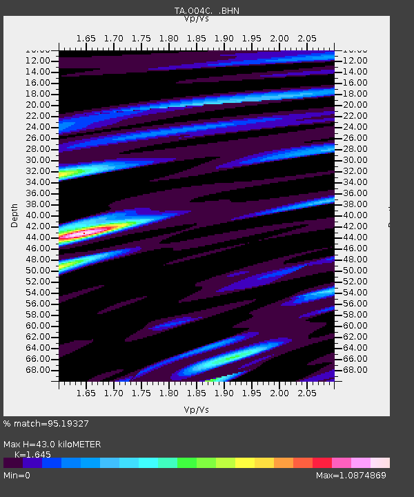
| Estimated Moho Depth: |
43.0 km |
| Estimated Crust Vp/Vs: |
1.64 |
| Assumed Crust Vp: |
6.566 km/s |
| Estimated Crust Vs: |
3.992 km/s |
| Estimated Crust Poisson's Ratio: |
0.21 |
|
| Radial Match: |
95.19327 % |
| Radial Bump: |
378 |
| Transverse Match: |
88.846985 % |
| Transverse Bump: |
400 |
| SOD ConfigId: |
2665 |
| Insert Time: |
2010-03-06 04:02:51.019 +0000 |
| GWidth: |
2.5 |
| Max Bumps: |
400 |
| Tol: |
0.001 |
|
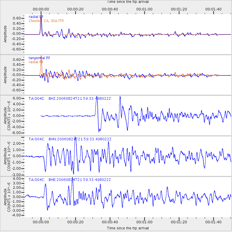
Signal To Noise
| Channel | StoN | STA | LTA |
| TA:O04C: :BHN:20060824T21:59:33.498022Z | 6.9134436 | 1.152302E-6 | 1.6667555E-7 |
| TA:O04C: :BHE:20060824T21:59:33.498022Z | 8.161335 | 1.5436524E-6 | 1.8914214E-7 |
| TA:O04C: :BHZ:20060824T21:59:33.498022Z | 42.849583 | 3.5795424E-6 | 8.353739E-8 |
| Arrivals |
| Ps | 4.5 SECOND |
| PpPs | 16 SECOND |
| PsPs/PpSs | 21 SECOND |


