You are here: Home > Network List > TA - USArray Transportable Network (new EarthScope stations) Stations List
> Station V35K Ketchikan, AK, USA > Earthquake Result Viewer
V35K Ketchikan, AK, USA - Earthquake Result Viewer
| Earthquake location: |
Off East Coast Of Honshu, Japan |
| Earthquake latitude/longitude: |
38.0/144.7 |
| Earthquake time(UTC): |
2017/09/20 (263) 16:37:16 GMT |
| Earthquake Depth: |
10 km |
| Earthquake Magnitude: |
6.1 Mww |
| Earthquake Catalog/Contributor: |
NEIC PDE/us |
|
| Network: |
TA USArray Transportable Network (new EarthScope stations) |
| Station: |
V35K Ketchikan, AK, USA |
| Lat/Lon: |
55.33 N/131.62 W |
| Elevation: |
64 m |
|
| Distance: |
56.5 deg |
| Az: |
42.953 deg |
| Baz: |
289.57 deg |
| Ray Param: |
0.06411977 |
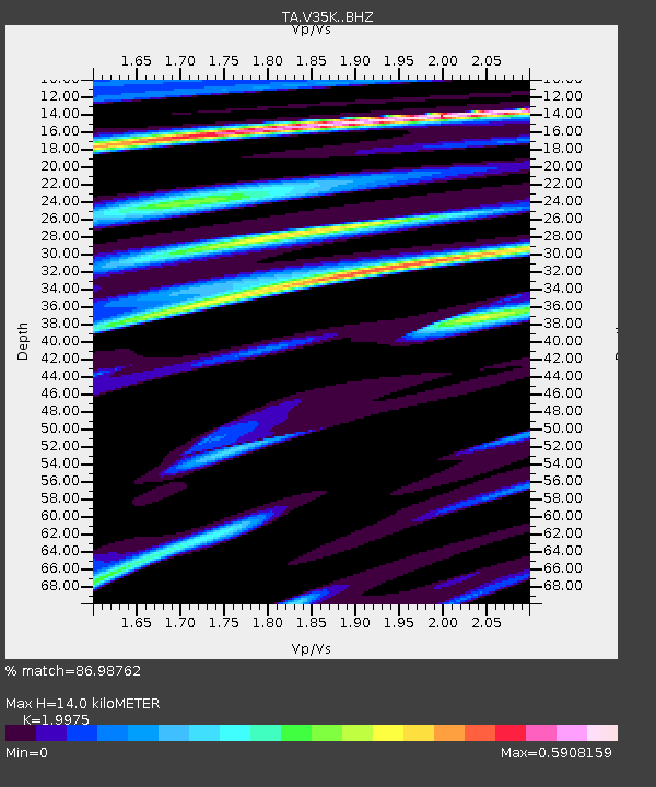
| Estimated Moho Depth: |
14.0 km |
| Estimated Crust Vp/Vs: |
2.00 |
| Assumed Crust Vp: |
6.545 km/s |
| Estimated Crust Vs: |
3.277 km/s |
| Estimated Crust Poisson's Ratio: |
0.33 |
|
| Radial Match: |
86.98762 % |
| Radial Bump: |
330 |
| Transverse Match: |
72.22894 % |
| Transverse Bump: |
400 |
| SOD ConfigId: |
13570011 |
| Insert Time: |
2019-04-28 20:19:25.649 +0000 |
| GWidth: |
2.5 |
| Max Bumps: |
400 |
| Tol: |
0.001 |
|
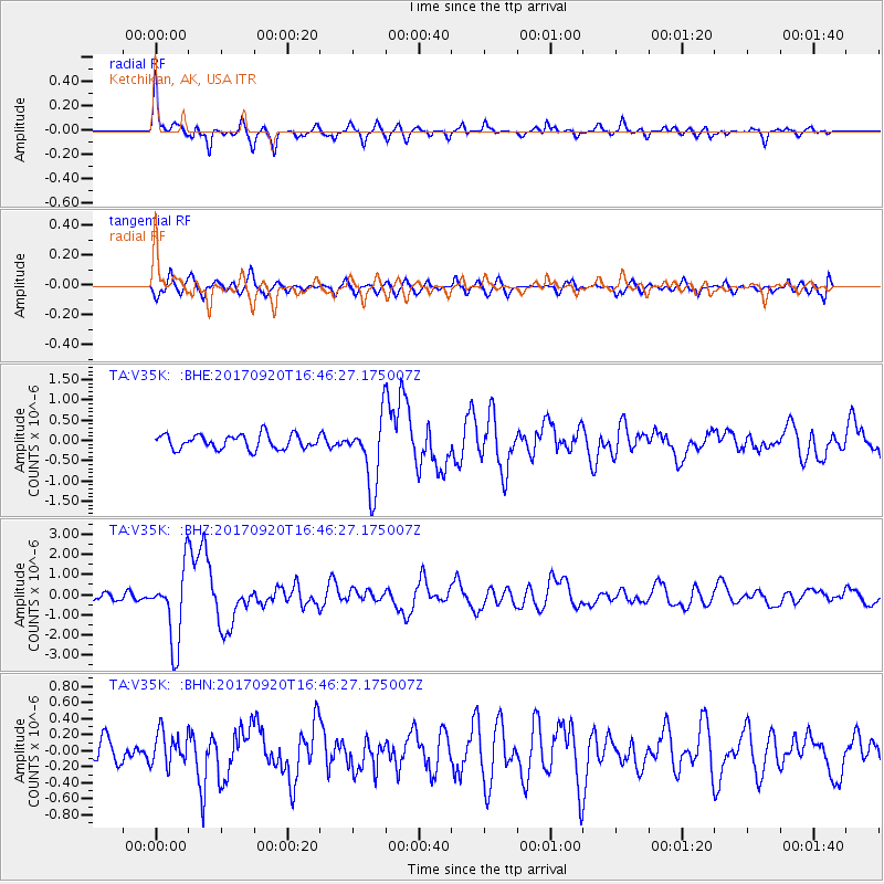
Signal To Noise
| Channel | StoN | STA | LTA |
| TA:V35K: :BHZ:20170920T16:46:27.175007Z | 8.016346 | 1.8535089E-6 | 2.3121619E-7 |
| TA:V35K: :BHN:20170920T16:46:27.175007Z | 1.4764513 | 2.0918495E-7 | 1.4168091E-7 |
| TA:V35K: :BHE:20170920T16:46:27.175007Z | 4.832827 | 8.538936E-7 | 1.7668616E-7 |
| Arrivals |
| Ps | 2.2 SECOND |
| PpPs | 6.1 SECOND |
| PsPs/PpSs | 8.4 SECOND |


