You are here: Home > Network List > IU - Global Seismograph Network (GSN - IRIS/USGS) Stations List
> Station CASY Casey, Antarctica > Earthquake Result Viewer
CASY Casey, Antarctica - Earthquake Result Viewer
| Earthquake location: |
Southwest Of Sumatra, Indonesia |
| Earthquake latitude/longitude: |
-4.9/94.2 |
| Earthquake time(UTC): |
2016/03/02 (062) 12:49:46 GMT |
| Earthquake Depth: |
10 km |
| Earthquake Magnitude: |
7.9 MWW |
| Earthquake Catalog/Contributor: |
NEIC PDE/NEIC COMCAT |
|
| Network: |
IU Global Seismograph Network (GSN - IRIS/USGS) |
| Station: |
CASY Casey, Antarctica |
| Lat/Lon: |
66.28 S/110.54 E |
| Elevation: |
10 m |
|
| Distance: |
62.3 deg |
| Az: |
172.634 deg |
| Baz: |
341.591 deg |
| Ray Param: |
0.060305275 |
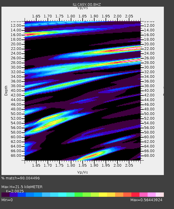
| Estimated Moho Depth: |
21.5 km |
| Estimated Crust Vp/Vs: |
2.08 |
| Assumed Crust Vp: |
6.356 km/s |
| Estimated Crust Vs: |
3.052 km/s |
| Estimated Crust Poisson's Ratio: |
0.35 |
|
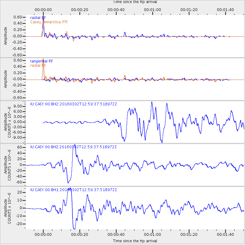
| Radial Match: |
98.084496 % |
| Radial Bump: |
344 |
| Transverse Match: |
93.282455 % |
| Transverse Bump: |
400 |
| SOD ConfigId: |
1427151 |
| Insert Time: |
2016-03-16 13:10:47.595 +0000 |
| GWidth: |
2.5 |
| Max Bumps: |
400 |
| Tol: |
0.001 |
|
Signal To Noise
| Channel | StoN | STA | LTA |
| IU:CASY:00:BHZ:20160302T12:59:37.518972Z | 14.042848 | 4.8939814E-6 | 3.4850348E-7 |
| IU:CASY:00:BH1:20160302T12:59:37.518972Z | 6.351032 | 2.404075E-6 | 3.7853297E-7 |
| IU:CASY:00:BH2:20160302T12:59:37.518972Z | 2.6334522 | 8.8905796E-7 | 3.376017E-7 |
| Arrivals |
| Ps | 3.8 SECOND |
| PpPs | 10 SECOND |
| PsPs/PpSs | 14 SECOND |


