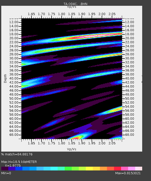
O04C Chester, CA, USA - Earthquake Result Viewer
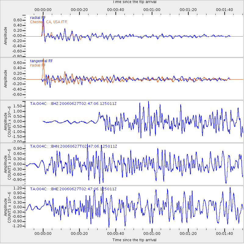
Earthquake location: Rat Islands, Aleutian Islands
Earthquake latitude/longitude: 52.2/176.2
Earthquake time(UTC): 2006/06/27 (178) 02:39:35 GMT
Earthquake Depth: 34 km
Earthquake Magnitude: 5.6 MB, 6.0 MS, 6.2 MW, 6.2 MW
Earthquake Catalog/Contributor: WHDF/NEIC
Network: TA USArray Transportable Network (new EarthScope stations)
Station: O04C Chester, CA, USA
Lat/Lon: 40.32 N/121.09 W
Elevation: 1513 m
Distance: 43.6 deg
Az: 79.943 deg
Baz: 307.578 deg
Ray Param: 0.07234651
Estimated Moho Depth: 18.5 km
Estimated Crust Vp/Vs: 1.98
Assumed Crust Vp: 6.566 km/s
Estimated Crust Vs: 3.32 km/s
Estimated Crust Poisson's Ratio: 0.33
Radial Match: 84.88176 %
Radial Bump: 373
Transverse Match: 67.19544 %
Transverse Bump: 400
SOD ConfigId: 2665
Insert Time: 2010-03-06 04:02:57.783 +0000
GWidth: 2.5
Max Bumps: 400
Tol: 0.001

Signal To Noise

ChannelStoNSTALTA
TA:O04C: :BHN:20060627T02:47:06.125011Z2.07417182.748229E-71.3249766E-7
TA:O04C: :BHE:20060627T02:47:06.125011Z1.19721422.447826E-72.0446016E-7
TA:O04C: :BHZ:20060627T02:47:06.125011Z6.72789144.848298E-77.206267E-8
Arrivals
Ps2.9 SECOND
PpPs7.9 SECOND
PsPs/PpSs11 SECOND