You are here: Home > Network List > IU - Global Seismograph Network (GSN - IRIS/USGS) Stations List
> Station PMG Port Moresby, New Guinea > Earthquake Result Viewer
PMG Port Moresby, New Guinea - Earthquake Result Viewer
| Earthquake location: |
Southwest Of Sumatra, Indonesia |
| Earthquake latitude/longitude: |
-4.9/94.2 |
| Earthquake time(UTC): |
2016/03/02 (062) 12:49:46 GMT |
| Earthquake Depth: |
10 km |
| Earthquake Magnitude: |
7.9 MWW |
| Earthquake Catalog/Contributor: |
NEIC PDE/NEIC COMCAT |
|
| Network: |
IU Global Seismograph Network (GSN - IRIS/USGS) |
| Station: |
PMG Port Moresby, New Guinea |
| Lat/Lon: |
9.40 S/147.16 E |
| Elevation: |
90 m |
|
| Distance: |
52.7 deg |
| Az: |
98.042 deg |
| Baz: |
270.988 deg |
| Ray Param: |
0.06661617 |
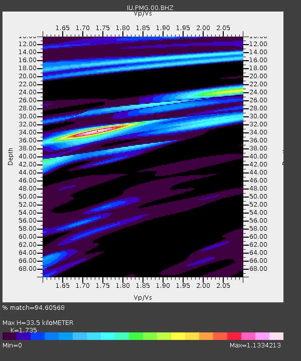
| Estimated Moho Depth: |
33.5 km |
| Estimated Crust Vp/Vs: |
1.74 |
| Assumed Crust Vp: |
6.122 km/s |
| Estimated Crust Vs: |
3.528 km/s |
| Estimated Crust Poisson's Ratio: |
0.25 |
|
| Radial Match: |
94.60568 % |
| Radial Bump: |
400 |
| Transverse Match: |
87.40555 % |
| Transverse Bump: |
400 |
| SOD ConfigId: |
1427151 |
| Insert Time: |
2016-03-16 13:11:15.872 +0000 |
| GWidth: |
2.5 |
| Max Bumps: |
400 |
| Tol: |
0.001 |
|

Signal To Noise
| Channel | StoN | STA | LTA |
| IU:PMG:00:BHZ:20160302T12:58:29.569021Z | 13.119098 | 2.9299017E-6 | 2.2333104E-7 |
| IU:PMG:00:BH1:20160302T12:58:29.569021Z | 5.2934175 | 3.113067E-7 | 5.881016E-8 |
| IU:PMG:00:BH2:20160302T12:58:29.569021Z | 8.0507765 | 1.197942E-6 | 1.4879832E-7 |
| Arrivals |
| Ps | 4.2 SECOND |
| PpPs | 14 SECOND |
| PsPs/PpSs | 18 SECOND |


