You are here: Home > Network List > UW - Pacific Northwest Regional Seismic Network Stations List
> Station YACT Amboy, WA, USA > Earthquake Result Viewer
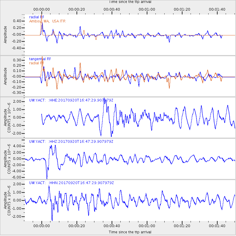
YACT Amboy, WA, USA - Earthquake Result Viewer
*The percent match for this event was below the threshold and hence no stack was calculated.
| Earthquake location: |
Off East Coast Of Honshu, Japan |
| Earthquake latitude/longitude: |
38.0/144.7 |
| Earthquake time(UTC): |
2017/09/20 (263) 16:37:16 GMT |
| Earthquake Depth: |
10 km |
| Earthquake Magnitude: |
6.1 Mww |
| Earthquake Catalog/Contributor: |
NEIC PDE/us |
|
| Network: |
UW Pacific Northwest Regional Seismic Network |
| Station: |
YACT Amboy, WA, USA |
| Lat/Lon: |
45.93 N/122.42 W |
| Elevation: |
211 m |
|
| Distance: |
65.7 deg |
| Az: |
49.866 deg |
| Baz: |
300.044 deg |
| Ray Param: |
$rayparam |
*The percent match for this event was below the threshold and hence was not used in the summary stack. |
|
| Radial Match: |
74.40101 % |
| Radial Bump: |
400 |
| Transverse Match: |
71.95557 % |
| Transverse Bump: |
400 |
| SOD ConfigId: |
13570011 |
| Insert Time: |
2019-04-28 20:20:44.867 +0000 |
| GWidth: |
2.5 |
| Max Bumps: |
400 |
| Tol: |
0.001 |
|
Signal To Noise
| Channel | StoN | STA | LTA |
| UW:YACT: :HHZ:20170920T16:47:29.907979Z | 9.5417185 | 2.3562134E-6 | 2.4693804E-7 |
| UW:YACT: :HHN:20170920T16:47:29.907979Z | 2.4044402 | 6.3008713E-7 | 2.620515E-7 |
| UW:YACT: :HHE:20170920T16:47:29.907979Z | 1.9413629 | 8.9925123E-7 | 4.6320616E-7 |
| Arrivals |
| Ps | |
| PpPs | |
| PsPs/PpSs | |


