You are here: Home > Network List > IU - Global Seismograph Network (GSN - IRIS/USGS) Stations List
> Station INCN Inchon, Republic of Korea > Earthquake Result Viewer
INCN Inchon, Republic of Korea - Earthquake Result Viewer
| Earthquake location: |
Southwest Of Sumatra, Indonesia |
| Earthquake latitude/longitude: |
-4.9/94.2 |
| Earthquake time(UTC): |
2016/03/02 (062) 12:49:46 GMT |
| Earthquake Depth: |
10 km |
| Earthquake Magnitude: |
7.9 MWW |
| Earthquake Catalog/Contributor: |
NEIC PDE/NEIC COMCAT |
|
| Network: |
IU Global Seismograph Network (GSN - IRIS/USGS) |
| Station: |
INCN Inchon, Republic of Korea |
| Lat/Lon: |
37.48 N/126.62 E |
| Elevation: |
55 m |
|
| Distance: |
51.8 deg |
| Az: |
32.82 deg |
| Baz: |
222.752 deg |
| Ray Param: |
0.0671519 |
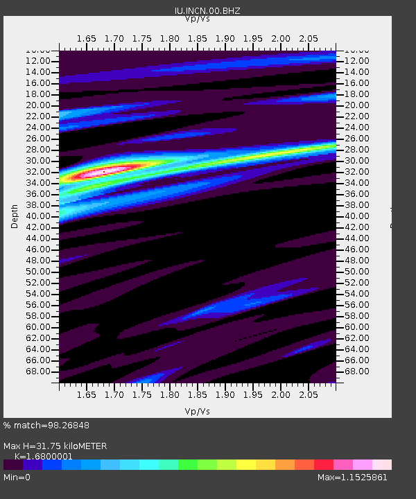
| Estimated Moho Depth: |
31.75 km |
| Estimated Crust Vp/Vs: |
1.68 |
| Assumed Crust Vp: |
6.459 km/s |
| Estimated Crust Vs: |
3.845 km/s |
| Estimated Crust Poisson's Ratio: |
0.23 |
|
| Radial Match: |
98.26848 % |
| Radial Bump: |
233 |
| Transverse Match: |
88.865715 % |
| Transverse Bump: |
400 |
| SOD ConfigId: |
1427151 |
| Insert Time: |
2016-03-16 13:11:51.634 +0000 |
| GWidth: |
2.5 |
| Max Bumps: |
400 |
| Tol: |
0.001 |
|

Signal To Noise
| Channel | StoN | STA | LTA |
| IU:INCN:00:BHZ:20160302T12:58:23.468984Z | 5.521576 | 2.6635478E-6 | 4.8238905E-7 |
| IU:INCN:00:BH1:20160302T12:58:23.468984Z | 4.6805396 | 1.3944987E-6 | 2.9793546E-7 |
| IU:INCN:00:BH2:20160302T12:58:23.468984Z | 5.35816 | 1.2329792E-6 | 2.3011242E-7 |
| Arrivals |
| Ps | 3.5 SECOND |
| PpPs | 12 SECOND |
| PsPs/PpSs | 16 SECOND |


