You are here: Home > Network List > ND - New CaleDonia Broadband Seismic Network Stations List
> Station OUENC Ouen island, New Caledonia > Earthquake Result Viewer
OUENC Ouen island, New Caledonia - Earthquake Result Viewer
| Earthquake location: |
Southwest Of Sumatra, Indonesia |
| Earthquake latitude/longitude: |
-4.9/94.2 |
| Earthquake time(UTC): |
2016/03/02 (062) 12:49:46 GMT |
| Earthquake Depth: |
10 km |
| Earthquake Magnitude: |
7.9 MWW |
| Earthquake Catalog/Contributor: |
NEIC PDE/NEIC COMCAT |
|
| Network: |
ND New CaleDonia Broadband Seismic Network |
| Station: |
OUENC Ouen island, New Caledonia |
| Lat/Lon: |
22.42 S/166.84 E |
| Elevation: |
115 m |
|
| Distance: |
72.1 deg |
| Az: |
111.864 deg |
| Baz: |
272.069 deg |
| Ray Param: |
0.053904597 |
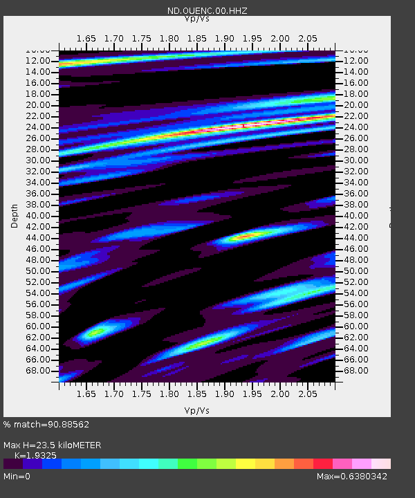
| Estimated Moho Depth: |
23.5 km |
| Estimated Crust Vp/Vs: |
1.93 |
| Assumed Crust Vp: |
5.14 km/s |
| Estimated Crust Vs: |
2.66 km/s |
| Estimated Crust Poisson's Ratio: |
0.32 |
|
| Radial Match: |
90.88562 % |
| Radial Bump: |
393 |
| Transverse Match: |
74.39657 % |
| Transverse Bump: |
400 |
| SOD ConfigId: |
1427151 |
| Insert Time: |
2016-03-16 13:12:53.782 +0000 |
| GWidth: |
2.5 |
| Max Bumps: |
400 |
| Tol: |
0.001 |
|
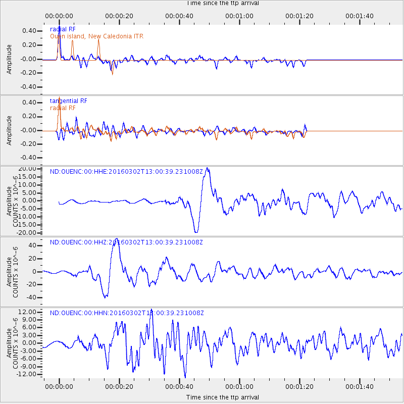
Signal To Noise
| Channel | StoN | STA | LTA |
| ND:OUENC:00:HHZ:20160302T13:00:39.231008Z | 1.6834388 | 2.0762006E-6 | 1.2333094E-6 |
| ND:OUENC:00:HHN:20160302T13:00:39.231008Z | 1.0187893 | 1.0237364E-6 | 1.0048559E-6 |
| ND:OUENC:00:HHE:20160302T13:00:39.231008Z | 0.8456179 | 6.140396E-7 | 7.261431E-7 |
| Arrivals |
| Ps | 4.4 SECOND |
| PpPs | 13 SECOND |
| PsPs/PpSs | 17 SECOND |


