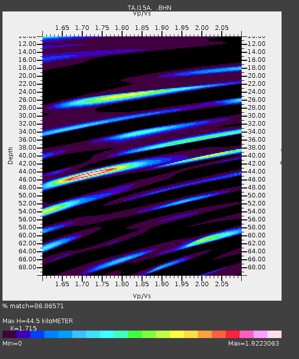
I15A Monteview, ID, USA - Earthquake Result Viewer

Earthquake location: Andreanof Islands, Aleutian Is.
Earthquake latitude/longitude: 51.9/-179.4
Earthquake time(UTC): 2008/04/15 (106) 22:59:51 GMT
Earthquake Depth: 10 km
Earthquake Magnitude: 6.1 MB, 6.4 MS, 6.4 MW, 6.4 MW
Earthquake Catalog/Contributor: WHDF/NEIC
Network: TA USArray Transportable Network (new EarthScope stations)
Station: I15A Monteview, ID, USA
Lat/Lon: 44.00 N/112.49 W
Elevation: 1470 m
Distance: 44.0 deg
Az: 72.677 deg
Baz: 304.869 deg
Ray Param: 0.07215918
Estimated Moho Depth: 44.5 km
Estimated Crust Vp/Vs: 1.72
Assumed Crust Vp: 6.279 km/s
Estimated Crust Vs: 3.661 km/s
Estimated Crust Poisson's Ratio: 0.24
Radial Match: 86.86571 %
Radial Bump: 400
Transverse Match: 77.670235 %
Transverse Bump: 400
SOD ConfigId: 2504
Insert Time: 2010-03-06 04:03:47.999 +0000
GWidth: 2.5
Max Bumps: 400
Tol: 0.001

Signal To Noise

ChannelStoNSTALTA
TA:I15A: :BHN:20080415T23:07:28.300012Z10.5853221.2952827E-61.2236592E-7
TA:I15A: :BHE:20080415T23:07:28.300012Z2.50392486.0555925E-72.4184402E-7
TA:I15A: :BHZ:20080415T23:07:28.300012Z2.78991068.095202E-72.901599E-7
Arrivals
Ps5.4 SECOND
PpPs18 SECOND
PsPs/PpSs23 SECOND