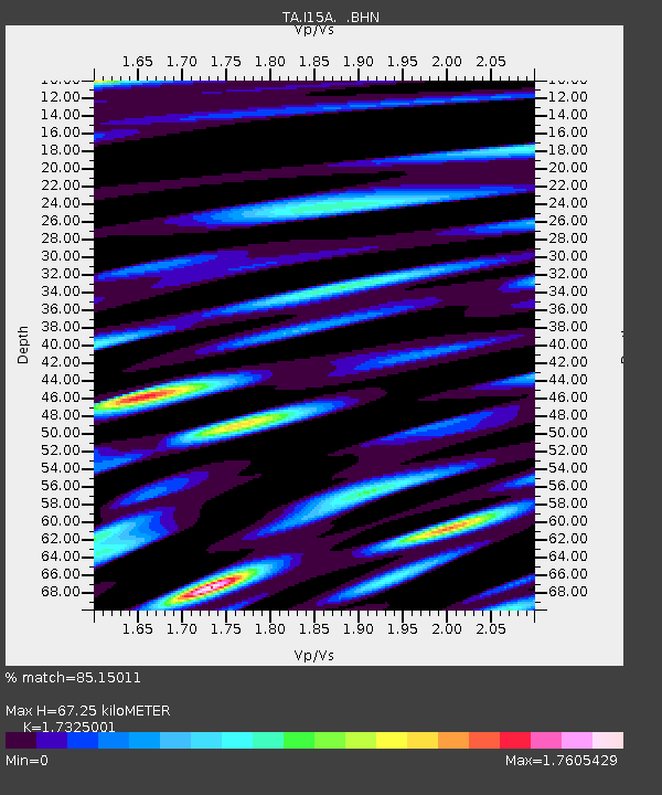
I15A Monteview, ID, USA - Earthquake Result Viewer
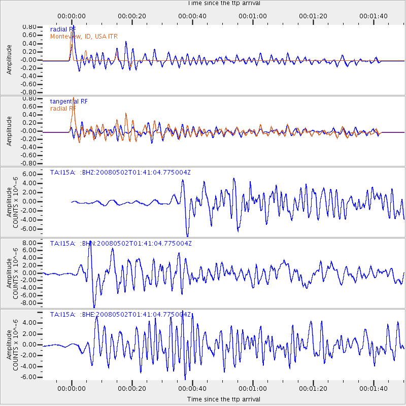
Earthquake location: Andreanof Islands, Aleutian Is.
Earthquake latitude/longitude: 51.9/-177.5
Earthquake time(UTC): 2008/05/02 (123) 01:33:37 GMT
Earthquake Depth: 14 km
Earthquake Magnitude: 6.3 MB, 6.8 MS, 6.6 MW, 6.6 MW
Earthquake Catalog/Contributor: WHDF/NEIC
Network: TA USArray Transportable Network (new EarthScope stations)
Station: I15A Monteview, ID, USA
Lat/Lon: 44.00 N/112.49 W
Elevation: 1470 m
Distance: 43.0 deg
Az: 73.778 deg
Baz: 304.408 deg
Ray Param: 0.07285052
Estimated Moho Depth: 67.25 km
Estimated Crust Vp/Vs: 1.73
Assumed Crust Vp: 6.279 km/s
Estimated Crust Vs: 3.624 km/s
Estimated Crust Poisson's Ratio: 0.25
Radial Match: 85.15011 %
Radial Bump: 400
Transverse Match: 70.13959 %
Transverse Bump: 400
SOD ConfigId: 2504
Insert Time: 2010-03-06 04:03:52.108 +0000
GWidth: 2.5
Max Bumps: 400
Tol: 0.001

Signal To Noise

ChannelStoNSTALTA
TA:I15A: :BHN:20080502T01:41:04.775004Z7.1293751.0494545E-61.4720146E-7
TA:I15A: :BHE:20080502T01:41:04.775004Z5.2961976.4442304E-71.2167656E-7
TA:I15A: :BHZ:20080502T01:41:04.775004Z2.52144727.603332E-73.0154635E-7
Arrivals
Ps8.4 SECOND
PpPs27 SECOND
PsPs/PpSs36 SECOND