I15A Monteview, ID, USA - Earthquake Result Viewer
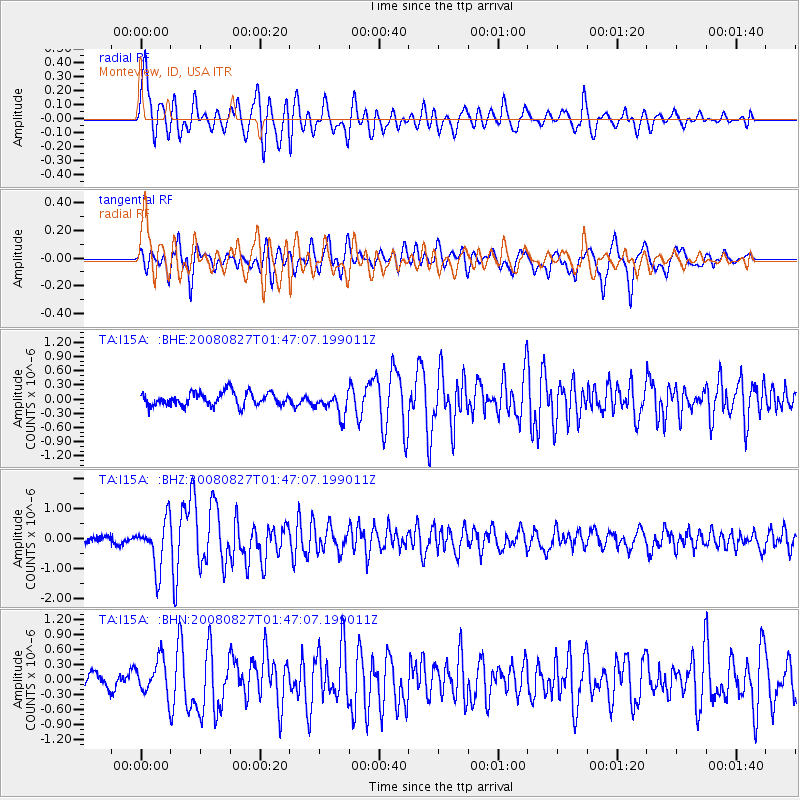
Earthquake location: Lake Baykal Region, Russia
Earthquake latitude/longitude: 51.6/104.2
Earthquake time(UTC): 2008/08/27 (240) 01:35:32 GMT
Earthquake Depth: 16 km
Earthquake Magnitude: 5.8 MB, 6.2 MS, 6.2 MW, 6.2 MW
Earthquake Catalog/Contributor: WHDF/NEIC
Network: TA USArray Transportable Network (new EarthScope stations)
Station: I15A Monteview, ID, USA
Lat/Lon: 44.00 N/112.49 W
Elevation: 1470 m
Distance: 79.6 deg
Az: 25.968 deg
Baz: 337.767 deg
Ray Param: 0.04881979
Estimated Moho Depth: 46.0 km
Estimated Crust Vp/Vs: 1.75
Assumed Crust Vp: 6.279 km/s
Estimated Crust Vs: 3.593 km/s
Estimated Crust Poisson's Ratio: 0.26
Radial Match: 85.16696 %
Radial Bump: 400
Transverse Match: 78.948616 %
Transverse Bump: 400
SOD ConfigId: 2504
Insert Time: 2010-03-06 04:04:18.692 +0000
GWidth: 2.5
Max Bumps: 400
Tol: 0.001

Signal To Noise

ChannelStoNSTALTA
TA:I15A: :BHZ:20080827T01:47:07.199011Z6.7834787.9506395E-71.1720596E-7
TA:I15A: :BHN:20080827T01:47:07.199011Z2.54563283.571361E-71.4029364E-7
TA:I15A: :BHE:20080827T01:47:07.199011Z1.74656632.4675E-71.4127721E-7
Arrivals
Ps5.6 SECOND
PpPs20 SECOND
PsPs/PpSs25 SECOND