You are here: Home > Network List > TA - USArray Transportable Network (new EarthScope stations) Stations List
> Station I15A Monteview, ID, USA > Earthquake Result Viewer
I15A Monteview, ID, USA - Earthquake Result Viewer
| Earthquake location: |
Tonga Islands |
| Earthquake latitude/longitude: |
-21.9/-173.8 |
| Earthquake time(UTC): |
2008/10/19 (293) 05:10:33 GMT |
| Earthquake Depth: |
29 km |
| Earthquake Magnitude: |
6.8 MB, 7.0 MS, 6.9 MW, 6.9 MW |
| Earthquake Catalog/Contributor: |
WHDF/NEIC |
|
| Network: |
TA USArray Transportable Network (new EarthScope stations) |
| Station: |
I15A Monteview, ID, USA |
| Lat/Lon: |
44.00 N/112.49 W |
| Elevation: |
1470 m |
|
| Distance: |
86.3 deg |
| Az: |
39.388 deg |
| Baz: |
234.768 deg |
| Ray Param: |
0.044146635 |
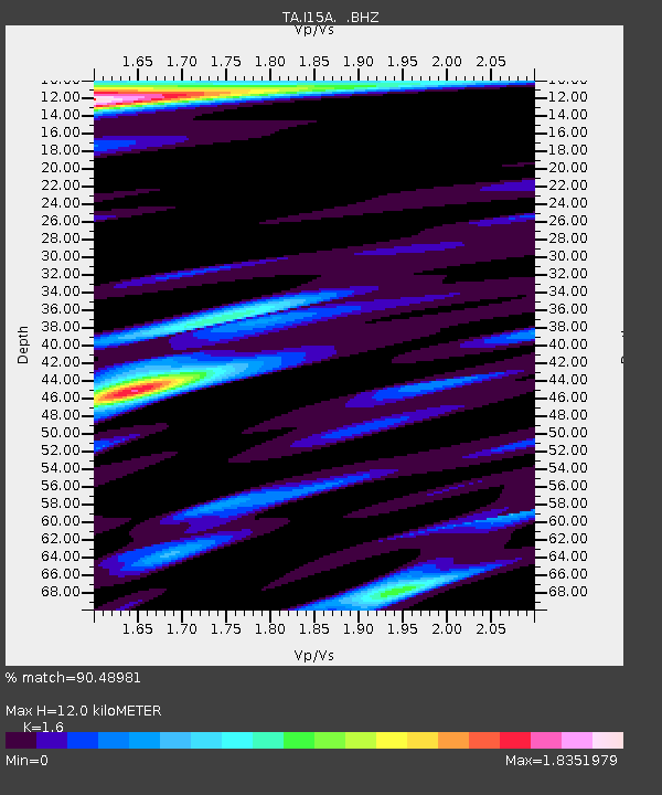
| Estimated Moho Depth: |
12.0 km |
| Estimated Crust Vp/Vs: |
1.60 |
| Assumed Crust Vp: |
6.279 km/s |
| Estimated Crust Vs: |
3.924 km/s |
| Estimated Crust Poisson's Ratio: |
0.18 |
|
| Radial Match: |
90.48981 % |
| Radial Bump: |
400 |
| Transverse Match: |
83.30444 % |
| Transverse Bump: |
400 |
| SOD ConfigId: |
2556 |
| Insert Time: |
2010-03-06 04:04:27.656 +0000 |
| GWidth: |
2.5 |
| Max Bumps: |
400 |
| Tol: |
0.001 |
|
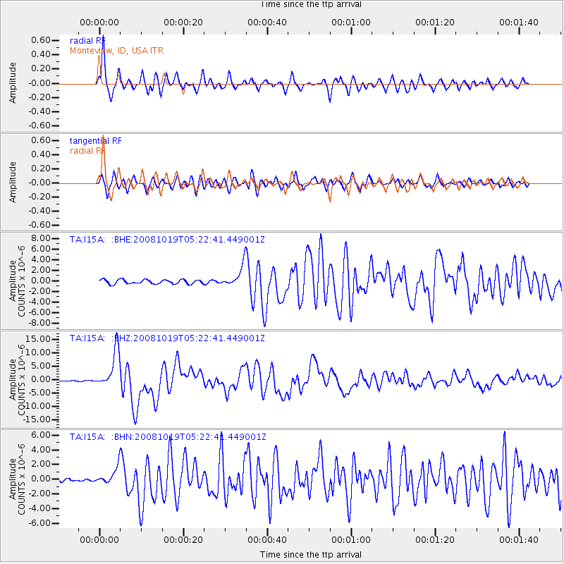
Signal To Noise
| Channel | StoN | STA | LTA |
| TA:I15A: :BHZ:20081019T05:22:41.449001Z | 61.78388 | 7.306952E-6 | 1.1826632E-7 |
| TA:I15A: :BHN:20081019T05:22:41.449001Z | 5.1131687 | 1.1709294E-6 | 2.2900268E-7 |
| TA:I15A: :BHE:20081019T05:22:41.449001Z | 5.51213 | 2.1555736E-6 | 3.9106004E-7 |
| Arrivals |
| Ps | 1.2 SECOND |
| PpPs | 4.8 SECOND |
| PsPs/PpSs | 6.0 SECOND |


