You are here: Home > Network List > TA - USArray Transportable Network (new EarthScope stations) Stations List
> Station I15A Monteview, ID, USA > Earthquake Result Viewer
I15A Monteview, ID, USA - Earthquake Result Viewer
| Earthquake location: |
Near Coast Of Northern Chile |
| Earthquake latitude/longitude: |
-20.2/-70.0 |
| Earthquake time(UTC): |
2008/02/04 (035) 17:01:30 GMT |
| Earthquake Depth: |
44 km |
| Earthquake Magnitude: |
6.0 MB, 6.2 MS, 6.3 MW, 6.3 MW |
| Earthquake Catalog/Contributor: |
WHDF/NEIC |
|
| Network: |
TA USArray Transportable Network (new EarthScope stations) |
| Station: |
I15A Monteview, ID, USA |
| Lat/Lon: |
44.00 N/112.49 W |
| Elevation: |
1470 m |
|
| Distance: |
74.7 deg |
| Az: |
329.679 deg |
| Baz: |
138.914 deg |
| Ray Param: |
0.052047662 |
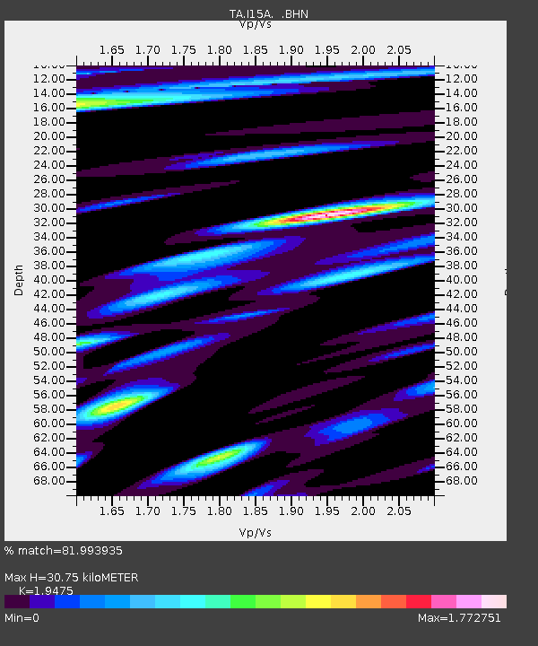
| Estimated Moho Depth: |
30.75 km |
| Estimated Crust Vp/Vs: |
1.95 |
| Assumed Crust Vp: |
6.279 km/s |
| Estimated Crust Vs: |
3.224 km/s |
| Estimated Crust Poisson's Ratio: |
0.32 |
|
| Radial Match: |
81.993935 % |
| Radial Bump: |
400 |
| Transverse Match: |
76.39065 % |
| Transverse Bump: |
400 |
| SOD ConfigId: |
2564 |
| Insert Time: |
2010-03-06 04:04:49.162 +0000 |
| GWidth: |
2.5 |
| Max Bumps: |
400 |
| Tol: |
0.001 |
|
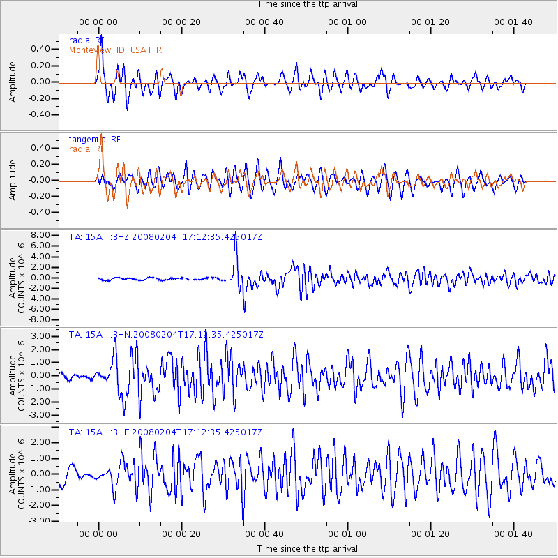
Signal To Noise
| Channel | StoN | STA | LTA |
| TA:I15A: :BHN:20080204T17:12:35.425017Z | 3.0153928 | 1.0245863E-6 | 3.3978534E-7 |
| TA:I15A: :BHE:20080204T17:12:35.425017Z | 1.6009238 | 6.085962E-7 | 3.8015315E-7 |
| TA:I15A: :BHZ:20080204T17:12:35.425017Z | 13.473565 | 2.7717233E-6 | 2.0571565E-7 |
| Arrivals |
| Ps | 4.8 SECOND |
| PpPs | 14 SECOND |
| PsPs/PpSs | 19 SECOND |


