You are here: Home > Network List > KS - Korea National Seismograph Network- KMA Stations List
> Station NAWB Namwon, South Korea > Earthquake Result Viewer
NAWB Namwon, South Korea - Earthquake Result Viewer
| Earthquake location: |
Vanuatu Islands |
| Earthquake latitude/longitude: |
-18.8/169.1 |
| Earthquake time(UTC): |
2017/09/20 (263) 20:09:49 GMT |
| Earthquake Depth: |
200 km |
| Earthquake Magnitude: |
6.4 mww |
| Earthquake Catalog/Contributor: |
NEIC PDE/us |
|
| Network: |
KS Korea National Seismograph Network- KMA |
| Station: |
NAWB Namwon, South Korea |
| Lat/Lon: |
35.42 N/127.40 E |
| Elevation: |
176 m |
|
| Distance: |
66.9 deg |
| Az: |
323.785 deg |
| Baz: |
136.743 deg |
| Ray Param: |
0.056750596 |
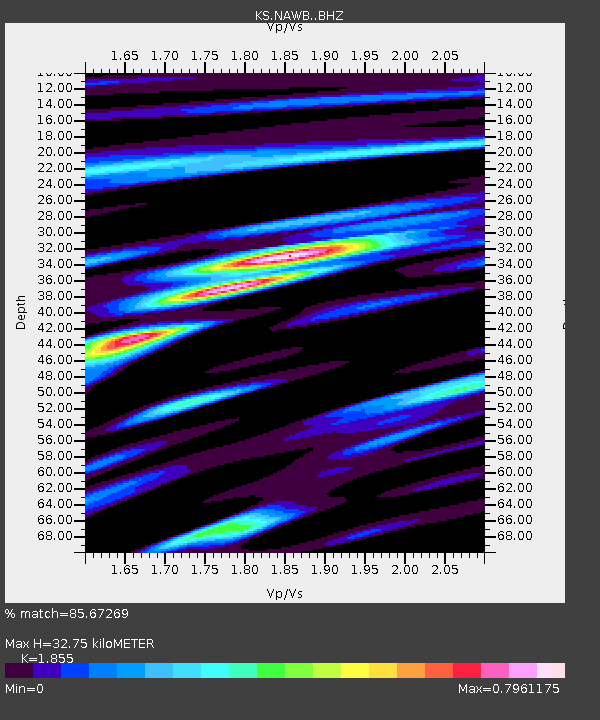
| Estimated Moho Depth: |
32.75 km |
| Estimated Crust Vp/Vs: |
1.86 |
| Assumed Crust Vp: |
6.459 km/s |
| Estimated Crust Vs: |
3.482 km/s |
| Estimated Crust Poisson's Ratio: |
0.30 |
|
| Radial Match: |
85.67269 % |
| Radial Bump: |
400 |
| Transverse Match: |
77.00062 % |
| Transverse Bump: |
400 |
| SOD ConfigId: |
13570011 |
| Insert Time: |
2019-04-28 20:26:26.431 +0000 |
| GWidth: |
2.5 |
| Max Bumps: |
400 |
| Tol: |
0.001 |
|

Signal To Noise
| Channel | StoN | STA | LTA |
| KS:NAWB: :BHZ:20170920T20:19:49.419009Z | 7.877424 | 1.7057007E-6 | 2.1653027E-7 |
| KS:NAWB: :BHN:20170920T20:19:49.419009Z | 2.415682 | 3.0569123E-7 | 1.2654449E-7 |
| KS:NAWB: :BHE:20170920T20:19:49.419009Z | 4.7644467 | 7.058993E-7 | 1.4815977E-7 |
| Arrivals |
| Ps | 4.5 SECOND |
| PpPs | 14 SECOND |
| PsPs/PpSs | 18 SECOND |


