You are here: Home > Network List > IU - Global Seismograph Network (GSN - IRIS/USGS) Stations List
> Station JOHN Johnston Island, USA > Earthquake Result Viewer
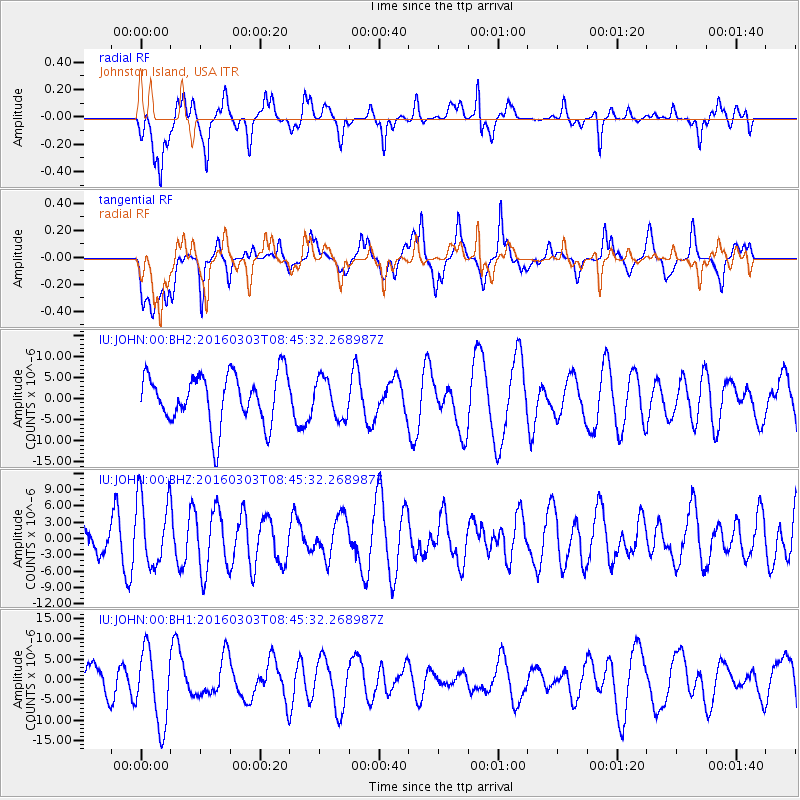
JOHN Johnston Island, USA - Earthquake Result Viewer
*The percent match for this event was below the threshold and hence no stack was calculated.
| Earthquake location: |
Timor Region |
| Earthquake latitude/longitude: |
-9.5/125.2 |
| Earthquake time(UTC): |
2016/03/03 (063) 08:34:56 GMT |
| Earthquake Depth: |
28 km |
| Earthquake Magnitude: |
5.6 MB |
| Earthquake Catalog/Contributor: |
NEIC PDE/NEIC COMCAT |
|
| Network: |
IU Global Seismograph Network (GSN - IRIS/USGS) |
| Station: |
JOHN Johnston Island, USA |
| Lat/Lon: |
16.73 N/169.53 W |
| Elevation: |
2.0 m |
|
| Distance: |
69.6 deg |
| Az: |
68.213 deg |
| Baz: |
252.936 deg |
| Ray Param: |
$rayparam |
*The percent match for this event was below the threshold and hence was not used in the summary stack. |
|
| Radial Match: |
46.067017 % |
| Radial Bump: |
374 |
| Transverse Match: |
58.95948 % |
| Transverse Bump: |
400 |
| SOD ConfigId: |
1427151 |
| Insert Time: |
2016-03-17 09:14:03.950 +0000 |
| GWidth: |
2.5 |
| Max Bumps: |
400 |
| Tol: |
0.001 |
|
Signal To Noise
| Channel | StoN | STA | LTA |
| IU:JOHN:00:BHZ:20160303T08:45:32.268987Z | 1.9035633 | 6.377833E-6 | 3.3504707E-6 |
| IU:JOHN:00:BH1:20160303T08:45:32.268987Z | 1.9461833 | 9.097573E-6 | 4.6745713E-6 |
| IU:JOHN:00:BH2:20160303T08:45:32.268987Z | 0.7810087 | 4.619367E-6 | 5.9146164E-6 |
| Arrivals |
| Ps | |
| PpPs | |
| PsPs/PpSs | |


