You are here: Home > Network List > NN - Western Great Basin/Eastern Sierra Nevada Stations List
> Station OMMB Old Mammoth Mine, surface, wgs-84 > Earthquake Result Viewer
OMMB Old Mammoth Mine, surface, wgs-84 - Earthquake Result Viewer
| Earthquake location: |
Vanuatu Islands |
| Earthquake latitude/longitude: |
-18.8/169.1 |
| Earthquake time(UTC): |
2017/09/20 (263) 20:09:49 GMT |
| Earthquake Depth: |
200 km |
| Earthquake Magnitude: |
6.4 mww |
| Earthquake Catalog/Contributor: |
NEIC PDE/us |
|
| Network: |
NN Western Great Basin/Eastern Sierra Nevada |
| Station: |
OMMB Old Mammoth Mine, surface, wgs-84 |
| Lat/Lon: |
37.61 N/119.00 W |
| Elevation: |
2768 m |
|
| Distance: |
87.8 deg |
| Az: |
49.063 deg |
| Baz: |
244.31 deg |
| Ray Param: |
0.042617664 |
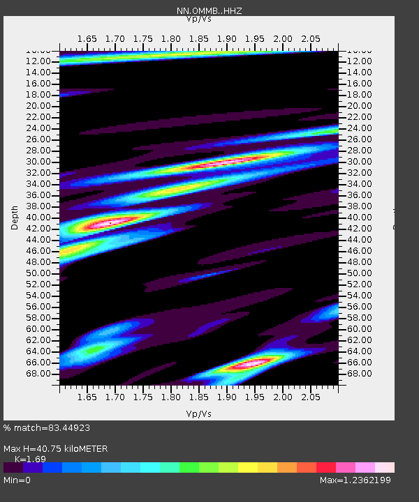
| Estimated Moho Depth: |
40.75 km |
| Estimated Crust Vp/Vs: |
1.69 |
| Assumed Crust Vp: |
6.291 km/s |
| Estimated Crust Vs: |
3.723 km/s |
| Estimated Crust Poisson's Ratio: |
0.23 |
|
| Radial Match: |
83.44923 % |
| Radial Bump: |
349 |
| Transverse Match: |
79.52899 % |
| Transverse Bump: |
292 |
| SOD ConfigId: |
13570011 |
| Insert Time: |
2019-04-28 20:26:43.956 +0000 |
| GWidth: |
2.5 |
| Max Bumps: |
400 |
| Tol: |
0.001 |
|

Signal To Noise
| Channel | StoN | STA | LTA |
| NN:OMMB: :HHZ:20170920T20:21:44.880007Z | 2.4828234 | 4.7998964E-7 | 1.9332413E-7 |
| NN:OMMB: :HHN:20170920T20:21:44.880007Z | 1.7800441 | 4.2958834E-7 | 2.4133578E-7 |
| NN:OMMB: :HHE:20170920T20:21:44.880007Z | 1.3692392 | 2.4092742E-7 | 1.7595715E-7 |
| Arrivals |
| Ps | 4.6 SECOND |
| PpPs | 17 SECOND |
| PsPs/PpSs | 22 SECOND |


