You are here: Home > Network List > S - Seismographs in Schools Projects Stations List
> Station AUNHS Nhulunbuy High School, NT > Earthquake Result Viewer
AUNHS Nhulunbuy High School, NT - Earthquake Result Viewer
| Earthquake location: |
Vanuatu Islands |
| Earthquake latitude/longitude: |
-18.8/169.1 |
| Earthquake time(UTC): |
2017/09/20 (263) 20:09:49 GMT |
| Earthquake Depth: |
200 km |
| Earthquake Magnitude: |
6.4 mww |
| Earthquake Catalog/Contributor: |
NEIC PDE/us |
|
| Network: |
S Seismographs in Schools Projects |
| Station: |
AUNHS Nhulunbuy High School, NT |
| Lat/Lon: |
12.19 S/136.78 E |
| Elevation: |
20 m |
|
| Distance: |
31.8 deg |
| Az: |
277.194 deg |
| Baz: |
106.003 deg |
| Ray Param: |
0.07831795 |
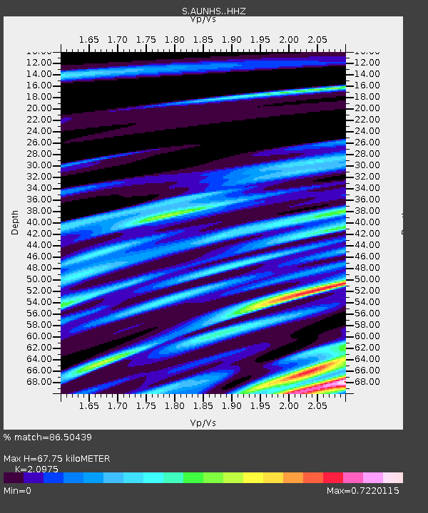
| Estimated Moho Depth: |
67.75 km |
| Estimated Crust Vp/Vs: |
2.10 |
| Assumed Crust Vp: |
6.472 km/s |
| Estimated Crust Vs: |
3.086 km/s |
| Estimated Crust Poisson's Ratio: |
0.35 |
|
| Radial Match: |
86.50439 % |
| Radial Bump: |
400 |
| Transverse Match: |
57.986458 % |
| Transverse Bump: |
400 |
| SOD ConfigId: |
13570011 |
| Insert Time: |
2019-04-28 20:27:21.728 +0000 |
| GWidth: |
2.5 |
| Max Bumps: |
400 |
| Tol: |
0.001 |
|

Signal To Noise
| Channel | StoN | STA | LTA |
| S:AUNHS: :HHZ:20170920T20:15:25.060Z | 5.622604 | 1.5418251E-6 | 2.7421905E-7 |
| S:AUNHS: :HHN:20170920T20:15:25.060Z | 1.546799 | 4.2669052E-7 | 2.758539E-7 |
| S:AUNHS: :HHE:20170920T20:15:25.060Z | 6.08217 | 1.6266323E-6 | 2.6744277E-7 |
| Arrivals |
| Ps | 12 SECOND |
| PpPs | 30 SECOND |
| PsPs/PpSs | 43 SECOND |


