You are here: Home > Network List > TA - USArray Transportable Network (new EarthScope stations) Stations List
> Station A21K Barrow, AK, USA > Earthquake Result Viewer
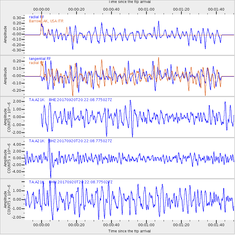
A21K Barrow, AK, USA - Earthquake Result Viewer
*The percent match for this event was below the threshold and hence no stack was calculated.
| Earthquake location: |
Vanuatu Islands |
| Earthquake latitude/longitude: |
-18.8/169.1 |
| Earthquake time(UTC): |
2017/09/20 (263) 20:09:49 GMT |
| Earthquake Depth: |
200 km |
| Earthquake Magnitude: |
6.4 mww |
| Earthquake Catalog/Contributor: |
NEIC PDE/us |
|
| Network: |
TA USArray Transportable Network (new EarthScope stations) |
| Station: |
A21K Barrow, AK, USA |
| Lat/Lon: |
71.32 N/156.62 W |
| Elevation: |
577 m |
|
| Distance: |
92.9 deg |
| Az: |
10.471 deg |
| Baz: |
212.301 deg |
| Ray Param: |
$rayparam |
*The percent match for this event was below the threshold and hence was not used in the summary stack. |
|
| Radial Match: |
56.144672 % |
| Radial Bump: |
400 |
| Transverse Match: |
59.341778 % |
| Transverse Bump: |
395 |
| SOD ConfigId: |
13570011 |
| Insert Time: |
2019-04-28 20:27:32.064 +0000 |
| GWidth: |
2.5 |
| Max Bumps: |
400 |
| Tol: |
0.001 |
|
Signal To Noise
| Channel | StoN | STA | LTA |
| TA:A21K: :BHZ:20170920T20:22:08.775027Z | 2.485782 | 2.0018635E-6 | 8.053255E-7 |
| TA:A21K: :BHN:20170920T20:22:08.775027Z | 1.411427 | 9.299111E-7 | 6.588446E-7 |
| TA:A21K: :BHE:20170920T20:22:08.775027Z | 0.60191476 | 4.7178594E-7 | 7.8380856E-7 |
| Arrivals |
| Ps | |
| PpPs | |
| PsPs/PpSs | |


