You are here: Home > Network List > TA - USArray Transportable Network (new EarthScope stations) Stations List
> Station I15A Monteview, ID, USA > Earthquake Result Viewer
I15A Monteview, ID, USA - Earthquake Result Viewer
| Earthquake location: |
Northern Chile |
| Earthquake latitude/longitude: |
-22.2/-69.9 |
| Earthquake time(UTC): |
2007/11/14 (318) 15:40:50 GMT |
| Earthquake Depth: |
40 km |
| Earthquake Magnitude: |
6.7 MB, 7.4 MS, 7.7 MW, 7.4 ME |
| Earthquake Catalog/Contributor: |
WHDF/NEIC |
|
| Network: |
TA USArray Transportable Network (new EarthScope stations) |
| Station: |
I15A Monteview, ID, USA |
| Lat/Lon: |
44.00 N/112.49 W |
| Elevation: |
1470 m |
|
| Distance: |
76.6 deg |
| Az: |
329.862 deg |
| Baz: |
139.868 deg |
| Ray Param: |
0.050815564 |
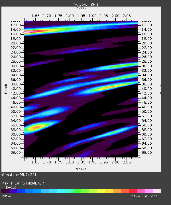
| Estimated Moho Depth: |
14.75 km |
| Estimated Crust Vp/Vs: |
1.60 |
| Assumed Crust Vp: |
6.279 km/s |
| Estimated Crust Vs: |
3.924 km/s |
| Estimated Crust Poisson's Ratio: |
0.18 |
|
| Radial Match: |
95.74241 % |
| Radial Bump: |
400 |
| Transverse Match: |
84.77958 % |
| Transverse Bump: |
400 |
| SOD ConfigId: |
2564 |
| Insert Time: |
2010-03-06 04:05:19.388 +0000 |
| GWidth: |
2.5 |
| Max Bumps: |
400 |
| Tol: |
0.001 |
|
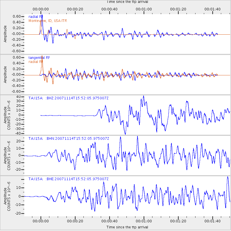
Signal To Noise
| Channel | StoN | STA | LTA |
| TA:I15A: :BHN:20071114T15:52:05.975007Z | 6.6337605 | 1.7400907E-6 | 2.6230836E-7 |
| TA:I15A: :BHE:20071114T15:52:05.975007Z | 6.028361 | 1.4954561E-6 | 2.4807008E-7 |
| TA:I15A: :BHZ:20071114T15:52:05.975007Z | 23.417051 | 5.7998805E-6 | 2.4767766E-7 |
| Arrivals |
| Ps | 1.5 SECOND |
| PpPs | 5.9 SECOND |
| PsPs/PpSs | 7.4 SECOND |


