You are here: Home > Network List > TA - USArray Transportable Network (new EarthScope stations) Stations List
> Station I15A Monteview, ID, USA > Earthquake Result Viewer
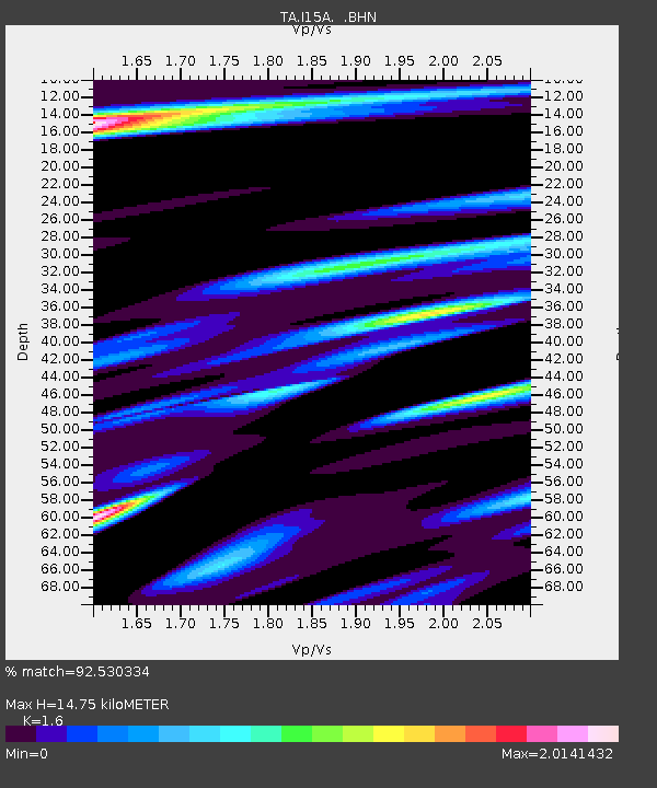
I15A Monteview, ID, USA - Earthquake Result Viewer
| Earthquake location: |
Near West Coast Of Colombia |
| Earthquake latitude/longitude: |
3.0/-78.0 |
| Earthquake time(UTC): |
2007/09/10 (253) 01:49:14 GMT |
| Earthquake Depth: |
31 km |
| Earthquake Magnitude: |
6.1 MB, 6.7 MS, 6.8 MW |
| Earthquake Catalog/Contributor: |
WHDF/NEIC |
|
| Network: |
TA USArray Transportable Network (new EarthScope stations) |
| Station: |
I15A Monteview, ID, USA |
| Lat/Lon: |
44.00 N/112.49 W |
| Elevation: |
1470 m |
|
| Distance: |
51.0 deg |
| Az: |
328.24 deg |
| Baz: |
133.248 deg |
| Ray Param: |
0.06764592 |
| Estimated Moho Depth: |
14.75 km |
| Estimated Crust Vp/Vs: |
1.60 |
| Assumed Crust Vp: |
6.279 km/s |
| Estimated Crust Vs: |
3.924 km/s |
| Estimated Crust Poisson's Ratio: |
0.18 |
|
| Radial Match: |
92.530334 % |
| Radial Bump: |
400 |
| Transverse Match: |
74.03705 % |
| Transverse Bump: |
400 |
| SOD ConfigId: |
2564 |
| Insert Time: |
2010-03-06 04:05:26.108 +0000 |
| GWidth: |
2.5 |
| Max Bumps: |
400 |
| Tol: |
0.001 |
|

Signal To Noise
| Channel | StoN | STA | LTA |
| TA:I15A: :BHN:20070910T01:57:42.29901Z | 2.2818027 | 7.0433094E-7 | 3.0867304E-7 |
| TA:I15A: :BHE:20070910T01:57:42.29901Z | 2.648598 | 8.038676E-7 | 3.0350682E-7 |
| TA:I15A: :BHZ:20070910T01:57:42.29901Z | 10.993293 | 1.6645484E-6 | 1.5141491E-7 |
| Arrivals |
| Ps | 1.5 SECOND |
| PpPs | 5.8 SECOND |
| PsPs/PpSs | 7.2 SECOND |


