You are here: Home > Network List > TA - USArray Transportable Network (new EarthScope stations) Stations List
> Station E18K Tukpahlearik Creek, AK, USA > Earthquake Result Viewer
E18K Tukpahlearik Creek, AK, USA - Earthquake Result Viewer
| Earthquake location: |
Vanuatu Islands |
| Earthquake latitude/longitude: |
-18.8/169.1 |
| Earthquake time(UTC): |
2017/09/20 (263) 20:09:49 GMT |
| Earthquake Depth: |
200 km |
| Earthquake Magnitude: |
6.4 mww |
| Earthquake Catalog/Contributor: |
NEIC PDE/us |
|
| Network: |
TA USArray Transportable Network (new EarthScope stations) |
| Station: |
E18K Tukpahlearik Creek, AK, USA |
| Lat/Lon: |
67.42 N/160.60 W |
| Elevation: |
297 m |
|
| Distance: |
88.8 deg |
| Az: |
11.238 deg |
| Baz: |
208.56 deg |
| Ray Param: |
0.041841034 |
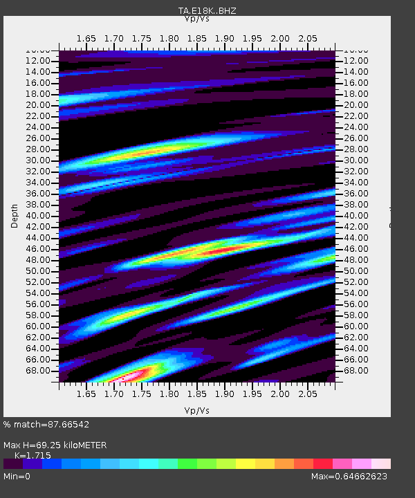
| Estimated Moho Depth: |
69.25 km |
| Estimated Crust Vp/Vs: |
1.72 |
| Assumed Crust Vp: |
6.276 km/s |
| Estimated Crust Vs: |
3.659 km/s |
| Estimated Crust Poisson's Ratio: |
0.24 |
|
| Radial Match: |
87.66542 % |
| Radial Bump: |
400 |
| Transverse Match: |
81.32589 % |
| Transverse Bump: |
400 |
| SOD ConfigId: |
13570011 |
| Insert Time: |
2019-04-28 20:27:54.729 +0000 |
| GWidth: |
2.5 |
| Max Bumps: |
400 |
| Tol: |
0.001 |
|
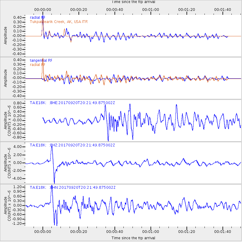
Signal To Noise
| Channel | StoN | STA | LTA |
| TA:E18K: :BHZ:20170920T20:21:49.875002Z | 11.123198 | 1.0825063E-6 | 9.7319706E-8 |
| TA:E18K: :BHN:20170920T20:21:49.875002Z | 5.0464435 | 3.301545E-7 | 6.54232E-8 |
| TA:E18K: :BHE:20170920T20:21:49.875002Z | 2.9576552 | 2.4546955E-7 | 8.2994646E-8 |
| Arrivals |
| Ps | 8.1 SECOND |
| PpPs | 29 SECOND |
| PsPs/PpSs | 37 SECOND |


