You are here: Home > Network List > TA - USArray Transportable Network (new EarthScope stations) Stations List
> Station E20K Nigu River, AK, USA > Earthquake Result Viewer
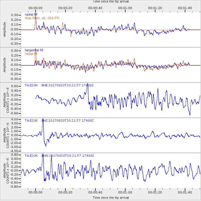
E20K Nigu River, AK, USA - Earthquake Result Viewer
*The percent match for this event was below the threshold and hence no stack was calculated.
| Earthquake location: |
Vanuatu Islands |
| Earthquake latitude/longitude: |
-18.8/169.1 |
| Earthquake time(UTC): |
2017/09/20 (263) 20:09:49 GMT |
| Earthquake Depth: |
200 km |
| Earthquake Magnitude: |
6.4 mww |
| Earthquake Catalog/Contributor: |
NEIC PDE/us |
|
| Network: |
TA USArray Transportable Network (new EarthScope stations) |
| Station: |
E20K Nigu River, AK, USA |
| Lat/Lon: |
68.26 N/156.19 W |
| Elevation: |
866 m |
|
| Distance: |
90.4 deg |
| Az: |
12.251 deg |
| Baz: |
212.652 deg |
| Ray Param: |
$rayparam |
*The percent match for this event was below the threshold and hence was not used in the summary stack. |
|
| Radial Match: |
74.57444 % |
| Radial Bump: |
400 |
| Transverse Match: |
71.52092 % |
| Transverse Bump: |
400 |
| SOD ConfigId: |
13570011 |
| Insert Time: |
2019-04-28 20:27:56.176 +0000 |
| GWidth: |
2.5 |
| Max Bumps: |
400 |
| Tol: |
0.001 |
|
Signal To Noise
| Channel | StoN | STA | LTA |
| TA:E20K: :BHZ:20170920T20:21:57.17499Z | 11.2096195 | 1.0400549E-6 | 9.2782365E-8 |
| TA:E20K: :BHN:20170920T20:21:57.17499Z | 2.366086 | 2.322399E-7 | 9.815361E-8 |
| TA:E20K: :BHE:20170920T20:21:57.17499Z | 2.885387 | 3.1111034E-7 | 1.0782275E-7 |
| Arrivals |
| Ps | |
| PpPs | |
| PsPs/PpSs | |


