You are here: Home > Network List > TA - USArray Transportable Network (new EarthScope stations) Stations List
> Station F20K Avaraart Lake, AK, USA > Earthquake Result Viewer
F20K Avaraart Lake, AK, USA - Earthquake Result Viewer
| Earthquake location: |
Vanuatu Islands |
| Earthquake latitude/longitude: |
-18.8/169.1 |
| Earthquake time(UTC): |
2017/09/20 (263) 20:09:49 GMT |
| Earthquake Depth: |
200 km |
| Earthquake Magnitude: |
6.4 mww |
| Earthquake Catalog/Contributor: |
NEIC PDE/us |
|
| Network: |
TA USArray Transportable Network (new EarthScope stations) |
| Station: |
F20K Avaraart Lake, AK, USA |
| Lat/Lon: |
67.05 N/155.73 W |
| Elevation: |
136 m |
|
| Distance: |
89.5 deg |
| Az: |
13.059 deg |
| Baz: |
213.081 deg |
| Ray Param: |
0.041697547 |
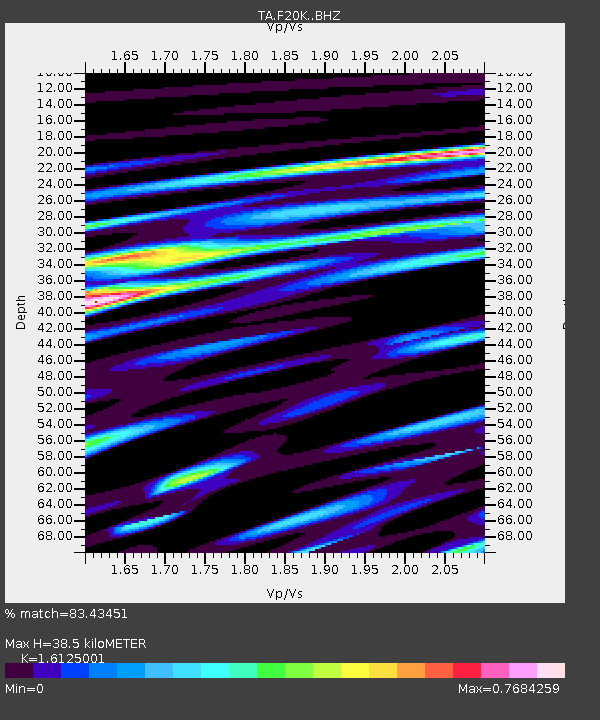
| Estimated Moho Depth: |
38.5 km |
| Estimated Crust Vp/Vs: |
1.61 |
| Assumed Crust Vp: |
6.522 km/s |
| Estimated Crust Vs: |
4.044 km/s |
| Estimated Crust Poisson's Ratio: |
0.19 |
|
| Radial Match: |
83.43451 % |
| Radial Bump: |
400 |
| Transverse Match: |
73.68538 % |
| Transverse Bump: |
400 |
| SOD ConfigId: |
13570011 |
| Insert Time: |
2019-04-28 20:28:06.274 +0000 |
| GWidth: |
2.5 |
| Max Bumps: |
400 |
| Tol: |
0.001 |
|

Signal To Noise
| Channel | StoN | STA | LTA |
| TA:F20K: :BHZ:20170920T20:21:52.900027Z | 16.000067 | 1.1288449E-6 | 7.055251E-8 |
| TA:F20K: :BHN:20170920T20:21:52.900027Z | 3.3487544 | 3.2284444E-7 | 9.640731E-8 |
| TA:F20K: :BHE:20170920T20:21:52.900027Z | 2.95985 | 2.3574138E-7 | 7.964639E-8 |
| Arrivals |
| Ps | 3.7 SECOND |
| PpPs | 15 SECOND |
| PsPs/PpSs | 19 SECOND |


