You are here: Home > Network List > TA - USArray Transportable Network (new EarthScope stations) Stations List
> Station G18K Tagagawik, AK, USA > Earthquake Result Viewer
G18K Tagagawik, AK, USA - Earthquake Result Viewer
| Earthquake location: |
Vanuatu Islands |
| Earthquake latitude/longitude: |
-18.8/169.1 |
| Earthquake time(UTC): |
2017/09/20 (263) 20:09:49 GMT |
| Earthquake Depth: |
200 km |
| Earthquake Magnitude: |
6.4 mww |
| Earthquake Catalog/Contributor: |
NEIC PDE/us |
|
| Network: |
TA USArray Transportable Network (new EarthScope stations) |
| Station: |
G18K Tagagawik, AK, USA |
| Lat/Lon: |
65.89 N/158.65 W |
| Elevation: |
484 m |
|
| Distance: |
87.9 deg |
| Az: |
12.669 deg |
| Baz: |
210.389 deg |
| Ray Param: |
0.042533595 |
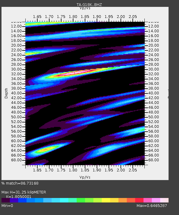
| Estimated Moho Depth: |
31.25 km |
| Estimated Crust Vp/Vs: |
1.81 |
| Assumed Crust Vp: |
6.1 km/s |
| Estimated Crust Vs: |
3.38 km/s |
| Estimated Crust Poisson's Ratio: |
0.28 |
|
| Radial Match: |
86.73168 % |
| Radial Bump: |
400 |
| Transverse Match: |
81.74232 % |
| Transverse Bump: |
400 |
| SOD ConfigId: |
13570011 |
| Insert Time: |
2019-04-28 20:28:15.524 +0000 |
| GWidth: |
2.5 |
| Max Bumps: |
400 |
| Tol: |
0.001 |
|

Signal To Noise
| Channel | StoN | STA | LTA |
| TA:G18K: :BHZ:20170920T20:21:45.400027Z | 12.263133 | 1.6190893E-6 | 1.32029E-7 |
| TA:G18K: :BHN:20170920T20:21:45.400027Z | 4.276793 | 3.913088E-7 | 9.149585E-8 |
| TA:G18K: :BHE:20170920T20:21:45.400027Z | 3.2069097 | 2.822043E-7 | 8.799883E-8 |
| Arrivals |
| Ps | 4.2 SECOND |
| PpPs | 14 SECOND |
| PsPs/PpSs | 18 SECOND |


