You are here: Home > Network List > TA - USArray Transportable Network (new EarthScope stations) Stations List
> Station G26K Porcupine River, AK, USA > Earthquake Result Viewer
G26K Porcupine River, AK, USA - Earthquake Result Viewer
| Earthquake location: |
Vanuatu Islands |
| Earthquake latitude/longitude: |
-18.8/169.1 |
| Earthquake time(UTC): |
2017/09/20 (263) 20:09:49 GMT |
| Earthquake Depth: |
200 km |
| Earthquake Magnitude: |
6.4 mww |
| Earthquake Catalog/Contributor: |
NEIC PDE/us |
|
| Network: |
TA USArray Transportable Network (new EarthScope stations) |
| Station: |
G26K Porcupine River, AK, USA |
| Lat/Lon: |
66.95 N/143.78 W |
| Elevation: |
180 m |
|
| Distance: |
92.3 deg |
| Az: |
16.785 deg |
| Baz: |
224.008 deg |
| Ray Param: |
0.04135989 |
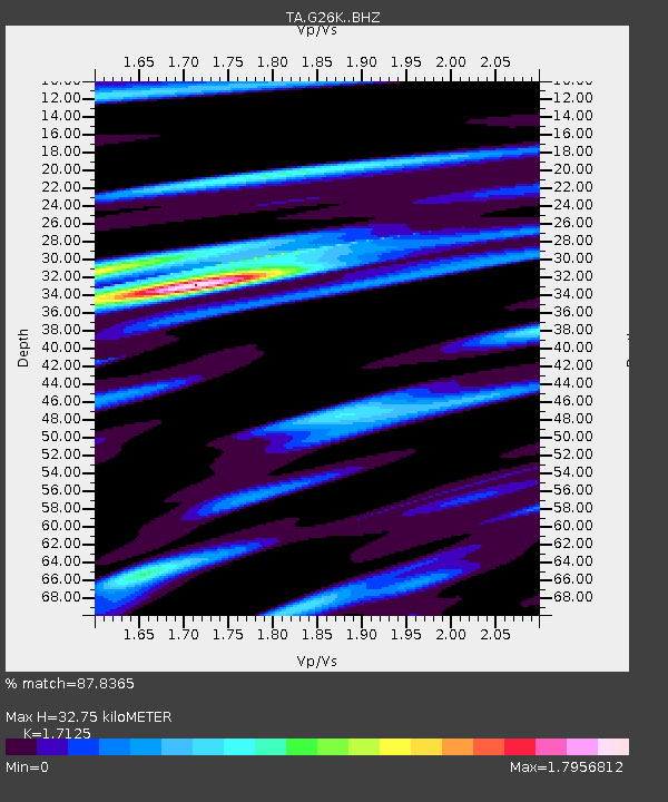
| Estimated Moho Depth: |
32.75 km |
| Estimated Crust Vp/Vs: |
1.71 |
| Assumed Crust Vp: |
6.577 km/s |
| Estimated Crust Vs: |
3.84 km/s |
| Estimated Crust Poisson's Ratio: |
0.24 |
|
| Radial Match: |
87.8365 % |
| Radial Bump: |
260 |
| Transverse Match: |
79.95891 % |
| Transverse Bump: |
293 |
| SOD ConfigId: |
13570011 |
| Insert Time: |
2019-04-28 20:28:18.856 +0000 |
| GWidth: |
2.5 |
| Max Bumps: |
400 |
| Tol: |
0.001 |
|

Signal To Noise
| Channel | StoN | STA | LTA |
| TA:G26K: :BHZ:20170920T20:22:06.025027Z | 23.973104 | 1.3199231E-6 | 5.5058496E-8 |
| TA:G26K: :BHN:20170920T20:22:06.025027Z | 2.439616 | 4.5558642E-7 | 1.8674514E-7 |
| TA:G26K: :BHE:20170920T20:22:06.025027Z | 3.504873 | 3.5165644E-7 | 1.0033357E-7 |
| Arrivals |
| Ps | 3.6 SECOND |
| PpPs | 13 SECOND |
| PsPs/PpSs | 17 SECOND |


