You are here: Home > Network List > TA - USArray Transportable Network (new EarthScope stations) Stations List
> Station K15K Wolf Creek Mountain, AK, USA > Earthquake Result Viewer
K15K Wolf Creek Mountain, AK, USA - Earthquake Result Viewer
| Earthquake location: |
Vanuatu Islands |
| Earthquake latitude/longitude: |
-18.8/169.1 |
| Earthquake time(UTC): |
2017/09/20 (263) 20:09:49 GMT |
| Earthquake Depth: |
200 km |
| Earthquake Magnitude: |
6.4 mww |
| Earthquake Catalog/Contributor: |
NEIC PDE/us |
|
| Network: |
TA USArray Transportable Network (new EarthScope stations) |
| Station: |
K15K Wolf Creek Mountain, AK, USA |
| Lat/Lon: |
62.29 N/161.53 W |
| Elevation: |
346 m |
|
| Distance: |
84.1 deg |
| Az: |
13.325 deg |
| Baz: |
207.849 deg |
| Ray Param: |
0.04523575 |
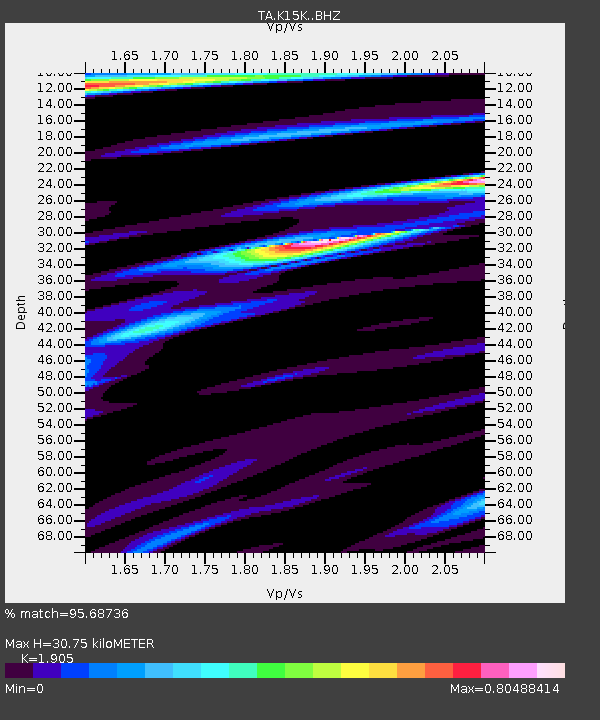
| Estimated Moho Depth: |
30.75 km |
| Estimated Crust Vp/Vs: |
1.90 |
| Assumed Crust Vp: |
6.276 km/s |
| Estimated Crust Vs: |
3.294 km/s |
| Estimated Crust Poisson's Ratio: |
0.31 |
|
| Radial Match: |
95.68736 % |
| Radial Bump: |
325 |
| Transverse Match: |
94.60326 % |
| Transverse Bump: |
319 |
| SOD ConfigId: |
13570011 |
| Insert Time: |
2019-04-28 20:28:49.021 +0000 |
| GWidth: |
2.5 |
| Max Bumps: |
400 |
| Tol: |
0.001 |
|

Signal To Noise
| Channel | StoN | STA | LTA |
| TA:K15K: :BHZ:20170920T20:21:27.025027Z | 8.142204 | 1.7508793E-6 | 2.150375E-7 |
| TA:K15K: :BHN:20170920T20:21:27.025027Z | 1.9210879 | 4.569924E-7 | 2.3788209E-7 |
| TA:K15K: :BHE:20170920T20:21:27.025027Z | 1.3318586 | 2.9000245E-7 | 2.1774265E-7 |
| Arrivals |
| Ps | 4.5 SECOND |
| PpPs | 14 SECOND |
| PsPs/PpSs | 18 SECOND |


