You are here: Home > Network List > TA - USArray Transportable Network (new EarthScope stations) Stations List
> Station L18K Granite Mountain, AK, USA > Earthquake Result Viewer
L18K Granite Mountain, AK, USA - Earthquake Result Viewer
| Earthquake location: |
Vanuatu Islands |
| Earthquake latitude/longitude: |
-18.8/169.1 |
| Earthquake time(UTC): |
2017/09/20 (263) 20:09:49 GMT |
| Earthquake Depth: |
200 km |
| Earthquake Magnitude: |
6.4 mww |
| Earthquake Catalog/Contributor: |
NEIC PDE/us |
|
| Network: |
TA USArray Transportable Network (new EarthScope stations) |
| Station: |
L18K Granite Mountain, AK, USA |
| Lat/Lon: |
62.22 N/156.69 W |
| Elevation: |
329 m |
|
| Distance: |
85.2 deg |
| Az: |
15.332 deg |
| Baz: |
212.316 deg |
| Ray Param: |
0.044476096 |
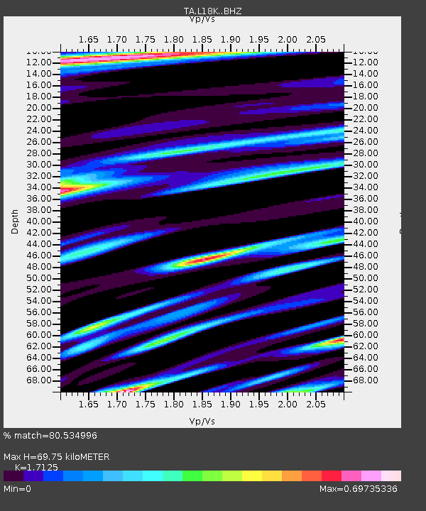
| Estimated Moho Depth: |
69.75 km |
| Estimated Crust Vp/Vs: |
1.71 |
| Assumed Crust Vp: |
6.182 km/s |
| Estimated Crust Vs: |
3.61 km/s |
| Estimated Crust Poisson's Ratio: |
0.24 |
|
| Radial Match: |
80.534996 % |
| Radial Bump: |
400 |
| Transverse Match: |
78.35695 % |
| Transverse Bump: |
400 |
| SOD ConfigId: |
13570011 |
| Insert Time: |
2019-04-28 20:28:54.993 +0000 |
| GWidth: |
2.5 |
| Max Bumps: |
400 |
| Tol: |
0.001 |
|

Signal To Noise
| Channel | StoN | STA | LTA |
| TA:L18K: :BHZ:20170920T20:21:32.349978Z | 4.8016086 | 1.0421953E-6 | 2.1705127E-7 |
| TA:L18K: :BHN:20170920T20:21:32.349978Z | 1.3751559 | 2.6160617E-7 | 1.9023747E-7 |
| TA:L18K: :BHE:20170920T20:21:32.349978Z | 1.2078619 | 1.8037404E-7 | 1.4933333E-7 |
| Arrivals |
| Ps | 8.2 SECOND |
| PpPs | 30 SECOND |
| PsPs/PpSs | 38 SECOND |


