You are here: Home > Network List > TA - USArray Transportable Network (new EarthScope stations) Stations List
> Station I15A Monteview, ID, USA > Earthquake Result Viewer
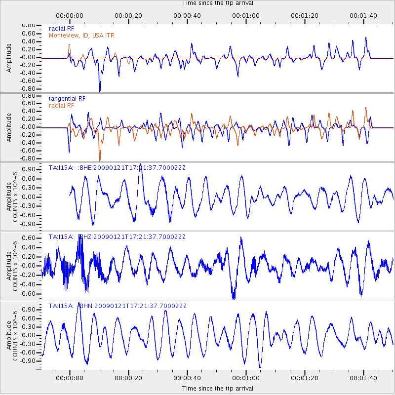
I15A Monteview, ID, USA - Earthquake Result Viewer
*The percent match for this event was below the threshold and hence no stack was calculated.
| Earthquake location: |
Southeast Of Loyalty Islands |
| Earthquake latitude/longitude: |
-22.7/171.0 |
| Earthquake time(UTC): |
2009/01/21 (021) 17:08:42 GMT |
| Earthquake Depth: |
24 km |
| Earthquake Magnitude: |
5.8 MS, 5.4 MB, 6.1 MW, 6.1 MW |
| Earthquake Catalog/Contributor: |
WHDF/NEIC |
|
| Network: |
TA USArray Transportable Network (new EarthScope stations) |
| Station: |
I15A Monteview, ID, USA |
| Lat/Lon: |
44.00 N/112.49 W |
| Elevation: |
1470 m |
|
| Distance: |
96.3 deg |
| Az: |
44.902 deg |
| Baz: |
244.602 deg |
| Ray Param: |
$rayparam |
*The percent match for this event was below the threshold and hence was not used in the summary stack. |
|
| Radial Match: |
58.935562 % |
| Radial Bump: |
367 |
| Transverse Match: |
41.653706 % |
| Transverse Bump: |
400 |
| SOD ConfigId: |
2834 |
| Insert Time: |
2010-03-06 04:06:50.406 +0000 |
| GWidth: |
2.5 |
| Max Bumps: |
400 |
| Tol: |
0.001 |
|
Signal To Noise
| Channel | StoN | STA | LTA |
| TA:I15A: :BHZ:20090121T17:21:37.700022Z | 1.4358811 | 2.8022288E-7 | 1.9515744E-7 |
| TA:I15A: :BHN:20090121T17:21:37.700022Z | 1.9085383 | 6.212683E-7 | 3.2552046E-7 |
| TA:I15A: :BHE:20090121T17:21:37.700022Z | 1.0321926 | 4.7058015E-7 | 4.5590346E-7 |
| Arrivals |
| Ps | |
| PpPs | |
| PsPs/PpSs | |


