You are here: Home > Network List > TA - USArray Transportable Network (new EarthScope stations) Stations List
> Station P17K Kvichak River, AK, USA > Earthquake Result Viewer
P17K Kvichak River, AK, USA - Earthquake Result Viewer
| Earthquake location: |
Vanuatu Islands |
| Earthquake latitude/longitude: |
-18.8/169.1 |
| Earthquake time(UTC): |
2017/09/20 (263) 20:09:49 GMT |
| Earthquake Depth: |
200 km |
| Earthquake Magnitude: |
6.4 mww |
| Earthquake Catalog/Contributor: |
NEIC PDE/us |
|
| Network: |
TA USArray Transportable Network (new EarthScope stations) |
| Station: |
P17K Kvichak River, AK, USA |
| Lat/Lon: |
59.20 N/156.44 W |
| Elevation: |
91 m |
|
| Distance: |
82.7 deg |
| Az: |
17.076 deg |
| Baz: |
212.718 deg |
| Ray Param: |
0.046231672 |
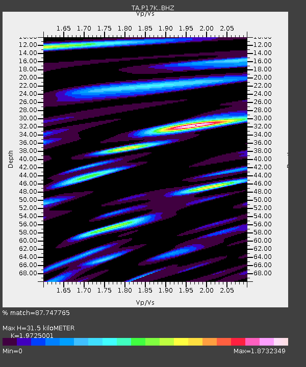
| Estimated Moho Depth: |
31.5 km |
| Estimated Crust Vp/Vs: |
1.97 |
| Assumed Crust Vp: |
6.276 km/s |
| Estimated Crust Vs: |
3.182 km/s |
| Estimated Crust Poisson's Ratio: |
0.33 |
|
| Radial Match: |
87.747765 % |
| Radial Bump: |
400 |
| Transverse Match: |
89.855934 % |
| Transverse Bump: |
400 |
| SOD ConfigId: |
13570011 |
| Insert Time: |
2019-04-28 20:29:28.022 +0000 |
| GWidth: |
2.5 |
| Max Bumps: |
400 |
| Tol: |
0.001 |
|
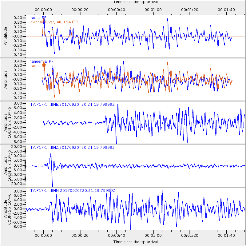
Signal To Noise
| Channel | StoN | STA | LTA |
| TA:P17K: :BHZ:20170920T20:21:19.79999Z | 31.91861 | 5.733533E-6 | 1.7962978E-7 |
| TA:P17K: :BHN:20170920T20:21:19.79999Z | 3.6382256 | 1.3953994E-6 | 3.8353846E-7 |
| TA:P17K: :BHE:20170920T20:21:19.79999Z | 2.016144 | 8.2158033E-7 | 4.0750083E-7 |
| Arrivals |
| Ps | 5.0 SECOND |
| PpPs | 15 SECOND |
| PsPs/PpSs | 20 SECOND |


