You are here: Home > Network List > TA - USArray Transportable Network (new EarthScope stations) Stations List
> Station Q16K King Salmon, AK, USA > Earthquake Result Viewer
Q16K King Salmon, AK, USA - Earthquake Result Viewer
| Earthquake location: |
Vanuatu Islands |
| Earthquake latitude/longitude: |
-18.8/169.1 |
| Earthquake time(UTC): |
2017/09/20 (263) 20:09:49 GMT |
| Earthquake Depth: |
200 km |
| Earthquake Magnitude: |
6.4 mww |
| Earthquake Catalog/Contributor: |
NEIC PDE/us |
|
| Network: |
TA USArray Transportable Network (new EarthScope stations) |
| Station: |
Q16K King Salmon, AK, USA |
| Lat/Lon: |
58.68 N/156.66 W |
| Elevation: |
22 m |
|
| Distance: |
82.2 deg |
| Az: |
17.263 deg |
| Baz: |
212.558 deg |
| Ray Param: |
0.046576466 |
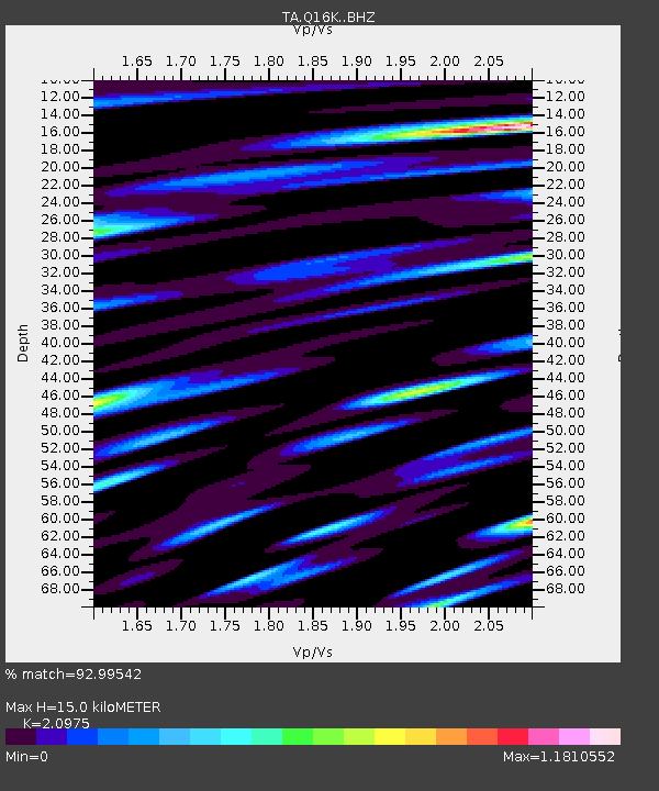
| Estimated Moho Depth: |
15.0 km |
| Estimated Crust Vp/Vs: |
2.10 |
| Assumed Crust Vp: |
6.276 km/s |
| Estimated Crust Vs: |
2.992 km/s |
| Estimated Crust Poisson's Ratio: |
0.35 |
|
| Radial Match: |
92.99542 % |
| Radial Bump: |
400 |
| Transverse Match: |
93.36941 % |
| Transverse Bump: |
356 |
| SOD ConfigId: |
13570011 |
| Insert Time: |
2019-04-28 20:29:33.888 +0000 |
| GWidth: |
2.5 |
| Max Bumps: |
400 |
| Tol: |
0.001 |
|

Signal To Noise
| Channel | StoN | STA | LTA |
| TA:Q16K: :BHZ:20170920T20:21:17.250002Z | 22.685402 | 6.341594E-6 | 2.7954516E-7 |
| TA:Q16K: :BHN:20170920T20:21:17.250002Z | 4.0165 | 2.0182981E-6 | 5.025017E-7 |
| TA:Q16K: :BHE:20170920T20:21:17.250002Z | 2.2410657 | 1.0127821E-6 | 4.5191985E-7 |
| Arrivals |
| Ps | 2.7 SECOND |
| PpPs | 7.3 SECOND |
| PsPs/PpSs | 9.9 SECOND |


