You are here: Home > Network List > TA - USArray Transportable Network (new EarthScope stations) Stations List
> Station R18K Karluk, AK, USA > Earthquake Result Viewer
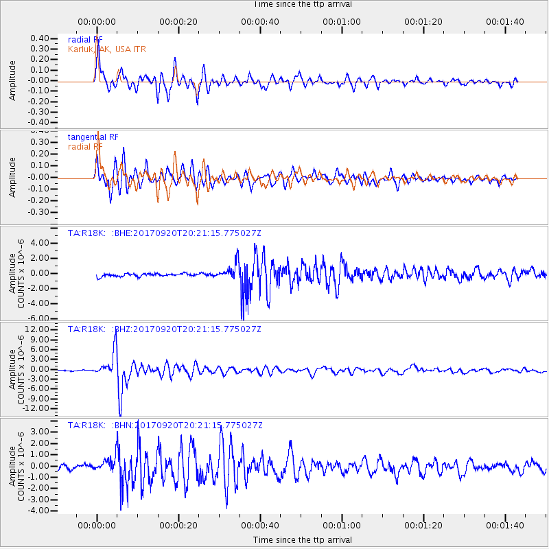
R18K Karluk, AK, USA - Earthquake Result Viewer
*The percent match for this event was below the threshold and hence no stack was calculated.
| Earthquake location: |
Vanuatu Islands |
| Earthquake latitude/longitude: |
-18.8/169.1 |
| Earthquake time(UTC): |
2017/09/20 (263) 20:09:49 GMT |
| Earthquake Depth: |
200 km |
| Earthquake Magnitude: |
6.4 mww |
| Earthquake Catalog/Contributor: |
NEIC PDE/us |
|
| Network: |
TA USArray Transportable Network (new EarthScope stations) |
| Station: |
R18K Karluk, AK, USA |
| Lat/Lon: |
57.57 N/154.45 W |
| Elevation: |
39 m |
|
| Distance: |
81.9 deg |
| Az: |
18.869 deg |
| Baz: |
214.647 deg |
| Ray Param: |
$rayparam |
*The percent match for this event was below the threshold and hence was not used in the summary stack. |
|
| Radial Match: |
92.414444 % |
| Radial Bump: |
367 |
| Transverse Match: |
90.87089 % |
| Transverse Bump: |
389 |
| SOD ConfigId: |
13570011 |
| Insert Time: |
2019-04-28 20:29:41.734 +0000 |
| GWidth: |
2.5 |
| Max Bumps: |
400 |
| Tol: |
0.001 |
|
Signal To Noise
| Channel | StoN | STA | LTA |
| TA:R18K: :BHZ:20170920T20:21:15.775027Z | 31.790642 | 4.146178E-6 | 1.3042134E-7 |
| TA:R18K: :BHN:20170920T20:21:15.775027Z | 3.889307 | 6.8801796E-7 | 1.7689989E-7 |
| TA:R18K: :BHE:20170920T20:21:15.775027Z | 6.3160496 | 1.1766012E-6 | 1.8628752E-7 |
| Arrivals |
| Ps | |
| PpPs | |
| PsPs/PpSs | |


