You are here: Home > Network List > TA - USArray Transportable Network (new EarthScope stations) Stations List
> Station V35K Ketchikan, AK, USA > Earthquake Result Viewer
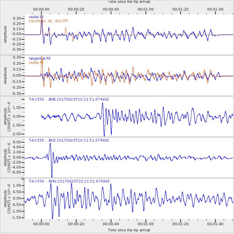
V35K Ketchikan, AK, USA - Earthquake Result Viewer
*The percent match for this event was below the threshold and hence no stack was calculated.
| Earthquake location: |
Vanuatu Islands |
| Earthquake latitude/longitude: |
-18.8/169.1 |
| Earthquake time(UTC): |
2017/09/20 (263) 20:09:49 GMT |
| Earthquake Depth: |
200 km |
| Earthquake Magnitude: |
6.4 mww |
| Earthquake Catalog/Contributor: |
NEIC PDE/us |
|
| Network: |
TA USArray Transportable Network (new EarthScope stations) |
| Station: |
V35K Ketchikan, AK, USA |
| Lat/Lon: |
55.33 N/131.62 W |
| Elevation: |
64 m |
|
| Distance: |
89.2 deg |
| Az: |
29.431 deg |
| Baz: |
234.543 deg |
| Ray Param: |
$rayparam |
*The percent match for this event was below the threshold and hence was not used in the summary stack. |
|
| Radial Match: |
69.1125 % |
| Radial Bump: |
306 |
| Transverse Match: |
66.97432 % |
| Transverse Bump: |
381 |
| SOD ConfigId: |
13570011 |
| Insert Time: |
2019-04-28 20:29:54.118 +0000 |
| GWidth: |
2.5 |
| Max Bumps: |
400 |
| Tol: |
0.001 |
|
Signal To Noise
| Channel | StoN | STA | LTA |
| TA:V35K: :BHZ:20170920T20:21:51.67499Z | 5.8019123 | 1.1980269E-6 | 2.0648827E-7 |
| TA:V35K: :BHN:20170920T20:21:51.67499Z | 1.5280484 | 3.3447802E-7 | 2.188923E-7 |
| TA:V35K: :BHE:20170920T20:21:51.67499Z | 1.2284561 | 2.5210537E-7 | 2.052213E-7 |
| Arrivals |
| Ps | |
| PpPs | |
| PsPs/PpSs | |


