You are here: Home > Network List > UW - Pacific Northwest Regional Seismic Network Stations List
> Station LCCR Mulino, OR, USA > Earthquake Result Viewer
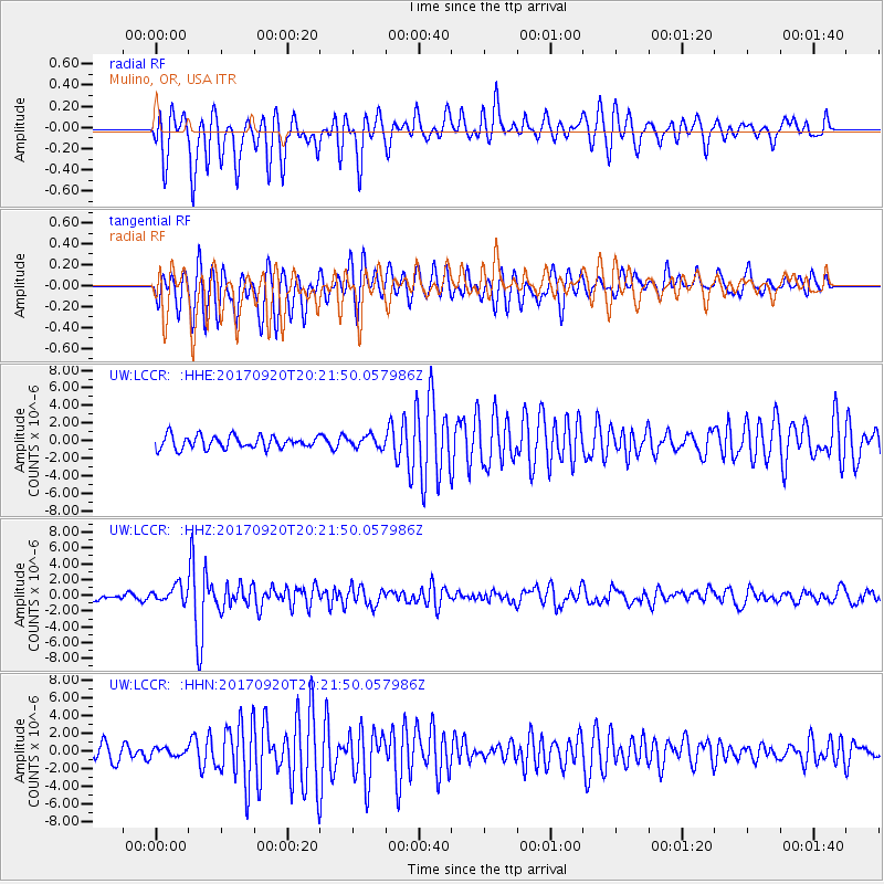
LCCR Mulino, OR, USA - Earthquake Result Viewer
*The percent match for this event was below the threshold and hence no stack was calculated.
| Earthquake location: |
Vanuatu Islands |
| Earthquake latitude/longitude: |
-18.8/169.1 |
| Earthquake time(UTC): |
2017/09/20 (263) 20:09:49 GMT |
| Earthquake Depth: |
200 km |
| Earthquake Magnitude: |
6.4 mww |
| Earthquake Catalog/Contributor: |
NEIC PDE/us |
|
| Network: |
UW Pacific Northwest Regional Seismic Network |
| Station: |
LCCR Mulino, OR, USA |
| Lat/Lon: |
45.21 N/122.48 W |
| Elevation: |
273 m |
|
| Distance: |
88.9 deg |
| Az: |
41.113 deg |
| Baz: |
241.779 deg |
| Ray Param: |
$rayparam |
*The percent match for this event was below the threshold and hence was not used in the summary stack. |
|
| Radial Match: |
82.72539 % |
| Radial Bump: |
378 |
| Transverse Match: |
78.160194 % |
| Transverse Bump: |
400 |
| SOD ConfigId: |
13570011 |
| Insert Time: |
2019-04-28 20:30:39.277 +0000 |
| GWidth: |
2.5 |
| Max Bumps: |
400 |
| Tol: |
0.001 |
|
Signal To Noise
| Channel | StoN | STA | LTA |
| UW:LCCR: :HHZ:20170920T20:21:50.057986Z | 2.3686273 | 1.017601E-6 | 4.2961634E-7 |
| UW:LCCR: :HHN:20170920T20:21:50.057986Z | 0.61796707 | 4.5623844E-7 | 7.3828926E-7 |
| UW:LCCR: :HHE:20170920T20:21:50.057986Z | 0.917682 | 6.6218814E-7 | 7.215878E-7 |
| Arrivals |
| Ps | |
| PpPs | |
| PsPs/PpSs | |


