You are here: Home > Network List > UW - Pacific Northwest Regional Seismic Network Stations List
> Station MRBL Marblemount, WA, USA > Earthquake Result Viewer
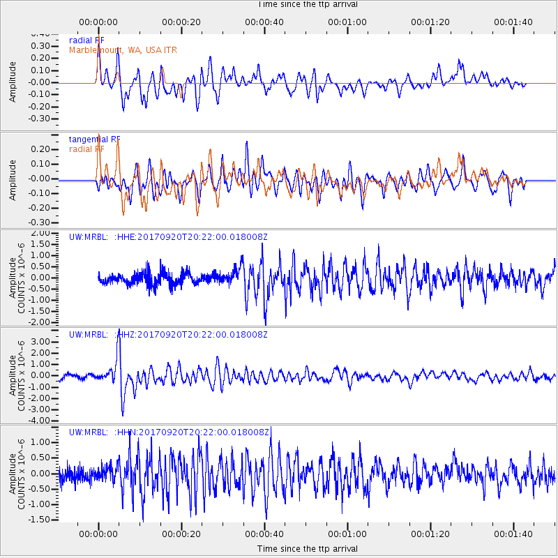
MRBL Marblemount, WA, USA - Earthquake Result Viewer
*The percent match for this event was below the threshold and hence no stack was calculated.
| Earthquake location: |
Vanuatu Islands |
| Earthquake latitude/longitude: |
-18.8/169.1 |
| Earthquake time(UTC): |
2017/09/20 (263) 20:09:49 GMT |
| Earthquake Depth: |
200 km |
| Earthquake Magnitude: |
6.4 mww |
| Earthquake Catalog/Contributor: |
NEIC PDE/us |
|
| Network: |
UW Pacific Northwest Regional Seismic Network |
| Station: |
MRBL Marblemount, WA, USA |
| Lat/Lon: |
48.52 N/121.48 W |
| Elevation: |
75 m |
|
| Distance: |
91.0 deg |
| Az: |
38.502 deg |
| Baz: |
242.5 deg |
| Ray Param: |
$rayparam |
*The percent match for this event was below the threshold and hence was not used in the summary stack. |
|
| Radial Match: |
74.57002 % |
| Radial Bump: |
400 |
| Transverse Match: |
76.8022 % |
| Transverse Bump: |
400 |
| SOD ConfigId: |
13570011 |
| Insert Time: |
2019-04-28 20:30:42.779 +0000 |
| GWidth: |
2.5 |
| Max Bumps: |
400 |
| Tol: |
0.001 |
|
Signal To Noise
| Channel | StoN | STA | LTA |
| UW:MRBL: :HHZ:20170920T20:22:00.018008Z | 6.0630174 | 1.1191308E-6 | 1.8458314E-7 |
| UW:MRBL: :HHN:20170920T20:22:00.018008Z | 0.9950118 | 2.2473569E-7 | 2.2586232E-7 |
| UW:MRBL: :HHE:20170920T20:22:00.018008Z | 1.4739015 | 3.77328E-7 | 2.5600625E-7 |
| Arrivals |
| Ps | |
| PpPs | |
| PsPs/PpSs | |


