You are here: Home > Network List > AV - Alaska Volcano Observatory Stations List
> Station MAPS Pakushin Southeast, Makushin Volcano, Alaska > Earthquake Result Viewer
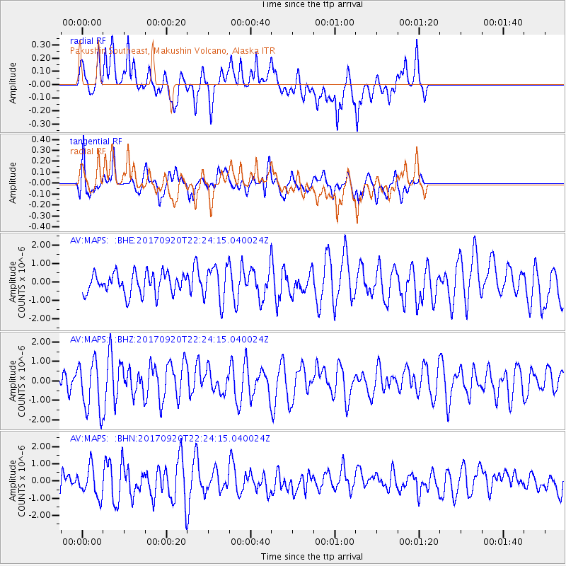
MAPS Pakushin Southeast, Makushin Volcano, Alaska - Earthquake Result Viewer
*The percent match for this event was below the threshold and hence no stack was calculated.
| Earthquake location: |
Eastern New Guinea Reg., P.N.G. |
| Earthquake latitude/longitude: |
-5.1/147.8 |
| Earthquake time(UTC): |
2017/09/20 (263) 22:13:36 GMT |
| Earthquake Depth: |
10 km |
| Earthquake Magnitude: |
5.9 Mww |
| Earthquake Catalog/Contributor: |
NEIC PDE/us |
|
| Network: |
AV Alaska Volcano Observatory |
| Station: |
MAPS Pakushin Southeast, Makushin Volcano, Alaska |
| Lat/Lon: |
53.81 N/166.94 W |
| Elevation: |
333 m |
|
| Distance: |
69.8 deg |
| Az: |
26.649 deg |
| Baz: |
228.878 deg |
| Ray Param: |
$rayparam |
*The percent match for this event was below the threshold and hence was not used in the summary stack. |
|
| Radial Match: |
56.441505 % |
| Radial Bump: |
400 |
| Transverse Match: |
48.839012 % |
| Transverse Bump: |
400 |
| SOD ConfigId: |
13570011 |
| Insert Time: |
2019-04-28 20:32:10.559 +0000 |
| GWidth: |
2.5 |
| Max Bumps: |
400 |
| Tol: |
0.001 |
|
Signal To Noise
| Channel | StoN | STA | LTA |
| AV:MAPS: :BHZ:20170920T22:24:15.040024Z | 2.4300413 | 1.332619E-6 | 5.483936E-7 |
| AV:MAPS: :BHN:20170920T22:24:15.040024Z | 1.4021226 | 8.6632787E-7 | 6.178688E-7 |
| AV:MAPS: :BHE:20170920T22:24:15.040024Z | 1.8265092 | 1.0122104E-6 | 5.541776E-7 |
| Arrivals |
| Ps | |
| PpPs | |
| PsPs/PpSs | |


