You are here: Home > Network List > CN - Canadian National Seismograph Network Stations List
> Station INK INUVIK, NT > Earthquake Result Viewer
INK INUVIK, NT - Earthquake Result Viewer
*The percent match for this event was below the threshold and hence no stack was calculated.
| Earthquake location: |
Eastern New Guinea Reg., P.N.G. |
| Earthquake latitude/longitude: |
-5.1/147.8 |
| Earthquake time(UTC): |
2017/09/20 (263) 22:13:36 GMT |
| Earthquake Depth: |
10 km |
| Earthquake Magnitude: |
5.9 Mww |
| Earthquake Catalog/Contributor: |
NEIC PDE/us |
|
| Network: |
CN Canadian National Seismograph Network |
| Station: |
INK INUVIK, NT |
| Lat/Lon: |
68.31 N/133.53 W |
| Elevation: |
44 m |
|
| Distance: |
90.5 deg |
| Az: |
21.378 deg |
| Baz: |
257.583 deg |
| Ray Param: |
$rayparam |
*The percent match for this event was below the threshold and hence was not used in the summary stack. |
|
| Radial Match: |
45.632168 % |
| Radial Bump: |
400 |
| Transverse Match: |
57.552685 % |
| Transverse Bump: |
400 |
| SOD ConfigId: |
13570011 |
| Insert Time: |
2019-04-28 20:33:07.180 +0000 |
| GWidth: |
2.5 |
| Max Bumps: |
400 |
| Tol: |
0.001 |
|
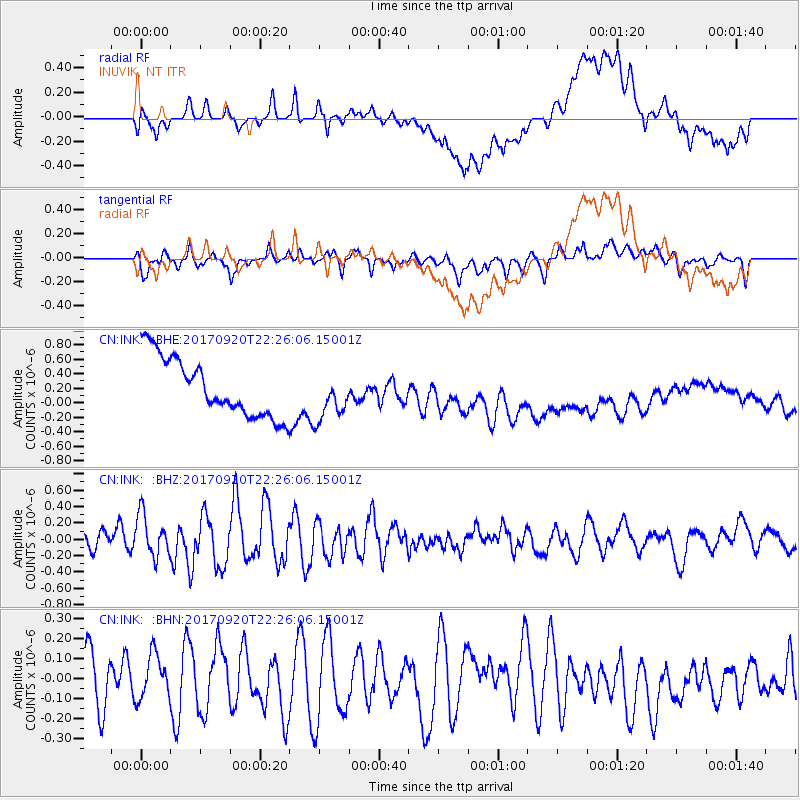
Signal To Noise
| Channel | StoN | STA | LTA |
| CN:INK: :BHZ:20170920T22:26:06.15001Z | 1.8107843 | 2.5898908E-7 | 1.430259E-7 |
| CN:INK: :BHN:20170920T22:26:06.15001Z | 0.86129117 | 1.11337506E-7 | 1.2926814E-7 |
| CN:INK: :BHE:20170920T22:26:06.15001Z | 0.6898494 | 2.7697152E-7 | 4.0149567E-7 |
| Arrivals |
| Ps | |
| PpPs | |
| PsPs/PpSs | |


